
A weather warning is in place with all parts of the country set to be hit by heavy rain and strong easterly winds coupled with sleet or snow on high ground.
Met Éireann said during Monday the rain will turn increasingly to sleet as it spreads north with snow on hills and possibly on lower ground too in northern areas.
The national status yellow rain and wind warning is in place until 6pm.
Sctd falls of rain for a time this morn, esp further N, with some wintry falls here. Brightening up a small bit later with brisk E winds easing too, however sctd heavy shwrs will follow. Highs of 8 to 12 deg across the S half of Ireland, colder elsewhere with highs of 3 to 7 deg. pic.twitter.com/XajhsAnfK8
— Met Éireann (@MetEireann) April 2, 2018
Drivers have also been advised to be careful due to the weather conditions and also because Easter Monday is traditionally a very busy day on the roads as people return home after the long Bank Holiday Weekend.
On Thursday evening at least 40 vehicles crashed as heavy hail showers swept over the country. A dozen collisions involving 36 vehicles on the M6, M7, M8, and M18 were reported to gardaí along with collisions in Cork, Dublin, and Co Limerick which were linked to the weather.
No one was killed in the crashes but there were a number of injuries and one casualty needed to be airlifted to hospital following a collision on the M7.
Multi-vehicle crashes
Chief superintendent Finbarr Murphy of the Garda National Roads Policing Bureau advised that "hailshowers pose significant risks to road users particularly on motorways. Drivers on motorways need to be vigilant and ready to stop when and if necessary and they need to be able to stop the vehicle safely in order to avoid collisions."
Chief supt Murphy added, “Hailshowers have resulted in multi-vehicle crashes recently. Please drive to the conditions, reduce your speed and increase your braking distance.”
"Hailstones are a year round occurrence in Ireland and can create very dangerous driving conditions due to their unpredictable and localised nature."
The Road Safety Authority (RSA) has produced a short video offering advice on how to deal with hailshowers. They recommend switching off cruise control when driving in hazardous weather conditions.
Anyone caught in a hailshower should: slow down without braking, use headlights, increase braking distance, use hazard lights to warn other motorists if necessary and avoid sudden steering or braking.
The outlook for the beginning of the week is for a cold spell with a mix of bright spells and showers.
Tuesday is forecast to be dry and bright with a few heavy showers and highest temperatures of 9 to 12 degrees.
Wednesday is expected to be mix of sunshine and showers and temperatures of 7 to 10 degrees before turning very cold that night with temperatures of -3.
Met Éireann forecaster Harm Luijkx said the continuing cold weather in Ireland was the result of atmospheric turbulence which had forced the jet stream to drift to the north of Ireland.
During this winter and spring the jet stream had become disturbed and “Ireland is stuck on the wrong side of it”, he said.
He said a similar weather phenomenon in 2013 had also resulted in a colder than normal spring.
When the jet stream is over Ireland it brings the mild and wet weather normally associated with this time of year.
UK weather warnings
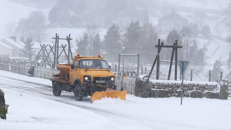
In the UK five weather warnings are in place as heavy rain and snow blight swathes of the country on Easter Monday.
Forecasters there have warned of treacherous driving conditions and travel disruption, with localised flooding in parts of southern England, Wales and Northern Ireland and up to 12cm of snow forecast across parts of northern England and southern Scotland.
Temperatures dipped as low as -7 degrees in the Scottish Highlands overnight while torrential rain moved in from the south and west amid milder conditions. Most of Wales, England and Northern Ireland is covered by a yellow warning for heavy rain, with up to 70mm expected to fall in some areas.
Around 150 flood alerts and 15 flood warnings were in place across England on Monday.
Meanwhile much of northern England and southern and central Scotland is covered by snow warnings.
There were concerns that some rural communities could become cut off, mainly across the northern Pennines and Scottish Borders, with “significant accumulations” of snow forecast.
The British Met Office said there was a chance of delays on roads, with some stranded vehicles and disruption to rail and air travel.
Forecaster Marco Petagna said: "With this rainfall we are certainly looking at some localised flooding in south-west England, Wales and Northern Ireland anywhere in the warning area.
“In terms of snow there could be travel problems on some Pennine routes and higher ground.”
For those who are travelling across Britain, warnings have been issued that train services could be disrupted and heavy traffic will take to the roads. – Additional reporting: PA


