
Hook Head offers two unique snorkelling spots, with a natural rock arch and the world’s oldest lighthouse as backdrops.
Scuba divers rate Hook Head among Ireland’s top places to dive. It offers plenty of scope for boat diving, with several wrecks fringing the west coast of the peninsula. But the area is also known for its shore dives, and along with the clear water and abundant sea life, it’s this accessibility that makes the area appealing to snorkellers.
Most of the best sites are concentrated at the southern tip of the peninsula, within a couple of kilometres of Hook Head Lighthouse. If you only have time for one outing, concentrate on the area immediately adjacent to the lighthouse.
This is a popular tourist site so don’t expect solitude, but it does provide a unique place to explore. Begin by walking to the end of the road beside the lighthouse. Continue on to the path that runs around the southern wall of the building, but after just 10m, veer right along the edge of a chasm. Cross the rocks for a further 50m to reach a large natural pool that’s almost enclosed by the surrounding reef.
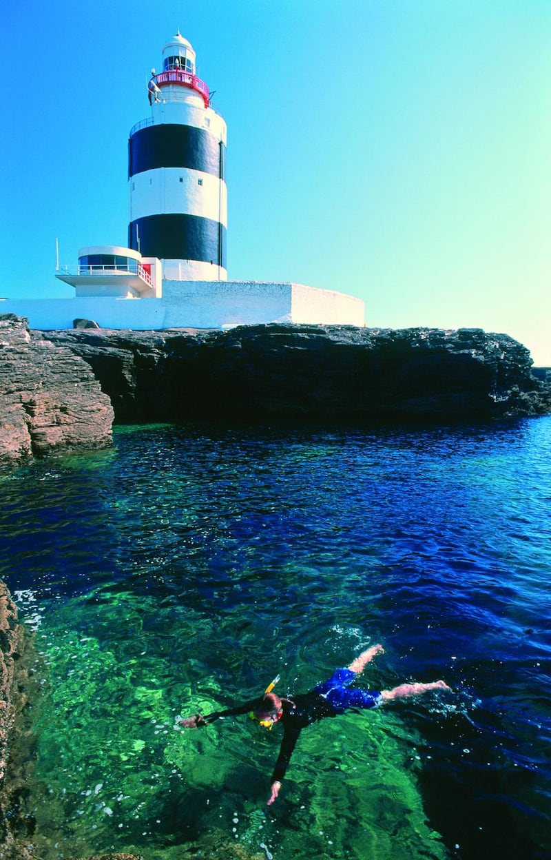
The rocky setting protects the pool from waves and currents, but you should still avoid swimming in stormy conditions. The pool itself offers great snorkelling at all but low tides. You should see plenty of underwater life amid the kelp and rocks, with some remarkably large spider crabs.
The reef here is limestone, which is easily eroded, so numerous gullies, chasms and holes provide shelter for fish. It’s a novel experience to lift your head and see the unmistakable tower of Ireland’s most famous lighthouse looming above. In calm seas it is possible to venture beyond the pool to the coastline beyond, but beware that a tidal race runs past this headland, so only attempt openwater excursions at slack water (an hour before low and high tide).
The snorkel – Solomon’s Hole
The other most interesting snorkelling site in the area is Solomon's Hole, which should be explored at mid to high tide. From Hook Head Lighthouse, you can reach this spot either by foot or by car. To walk there, head along the path that skirts around the southern walls of the lighthouse compound, then continue northeast along a delightful section of the Wexford Coastal Path.
This grassy trail leads along the top of the foreshore and brings you to Solomon's Hole after 2km. Alternatively, drive the 2.5km and park at Slade Harbour. Head through a stone archway at the southeastern corner of the harbour, then cross a stile and head south along the Wexford Coastal Path. After roughly 300m, shortly before the next stile, you will notice the numbers 11 and 12 painted on the shoreside rocks.
Solomon’s Hole lies beneath the arch just right of number 12. This excursion is more memorable for its remarkable geology than its underwater life. The hole itself is a small enclosed pool that has formed beneath a natural rock arch.
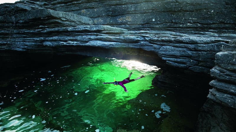
A sloping ledge allows easy access to the back of the pool, which deepens as it nears the arch. At mid tide there’s plenty of headroom to swim underneath, but at very high tide you may have to duck underwater to pass through. On the far side of the arch, the channel narrows to a slender gully, 12m deep but just 2m wide. Divers attest to the lobsters, crab and wrasse that shelter here. In calm conditions you can exit the gully and explore the coastline beyond, before squeezing back though the chasm and under the arch to finish. Before leaving, make sure to walk over the top of the arch too, just to say you’ve explored it from every possible angle.
Great for:
– Watching spider crabs scuttle across a sheltered pool beneath the lighthouse.
– Ducking under a natural rock arch at Solomon’s Hole.
Conditions:
– Calm seas
Access – Hook Head Lighthouse:
– Park at the car park for Hook Head Lighthouse, at the southern tip of the Hook Peninsula.
– Map: OSi 1:50,000 sheet 76
– Grid Ref: X 733 973
– GPS: 52.123991, -6.930594
Access – Slade Harbour:
– Park beside Slade Harbour, which is signed to the east from the roundabout just 2km before Hook Head Lighthouse.
– Map: OSi 1:50,000 sheet 76
– Grid Ref: X 746 985
– GPS: 52.134260, -6.910852
An edited extract of one of 50 activities in Ireland's Adventure Bucket List - Great Outdoor Experiences by Helen Fairbairn. Published by The Collins Press
All photographs: garethmccormack.com


