
Concerns have been raised about "ferocious and very dangerous" surges around coastal areas as Storm Lorenzo is expected to track across Ireland during Thursday night and into Friday morning.
The Government has directed various arms of the State to be on standby with the storm expected to bring high seas, severe winds and heavy rain.
Lorenzo is at present a category two hurricane and is situated about 3,000km southwest of Ireland.
This just happened in Kilmainham. It’s like a bomb hit it. Heard the bang from a café round the corner. Lucky nobody was passing it at the time. pic.twitter.com/Jm66vauPKy
— Frank McNally (@FrankmcnallyIT) October 1, 2019
Met Éireann has issued an advisory for very wet and potentially stormy conditions from midday on Thursday until noon on Friday, and said weather warnings will be issued on Wednesday morning.
Liz Gavin, Met Éireann meteorologist, said there remains "considerable spread" in the possible track of Hurricane Lorenzo as it weakens to extra-tropical storm status.
“As it tracks northeastwards in the Atlantic basin and it meets the cooler waters of the north Atlantic, Lorenzo will lose a lot of its strength and it will transition to an extra tropical cyclone around 1,000km off the south west coast,” she said.
Met Éireann's latest update on Hurricane Lorenzo says it is expected to bring "hurricane conditions" (category one) to western parts of the Azores on Tuesday night and into Wednesday, with both hurricane and tropical storm warnings in effect there.
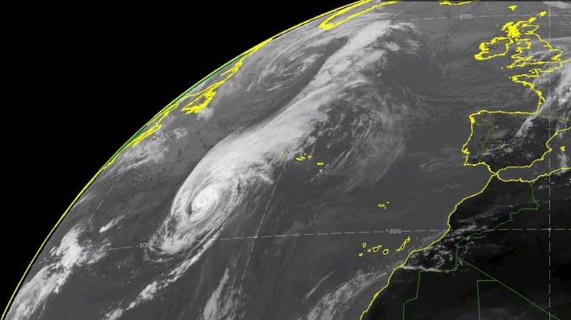
“Very high/phenomenal seas will be generated on the eastern side of Lorenzo as it tracks north-northeastwards over the coming days, with swells currently spreading across much of the North Atlantic basin,” it said.
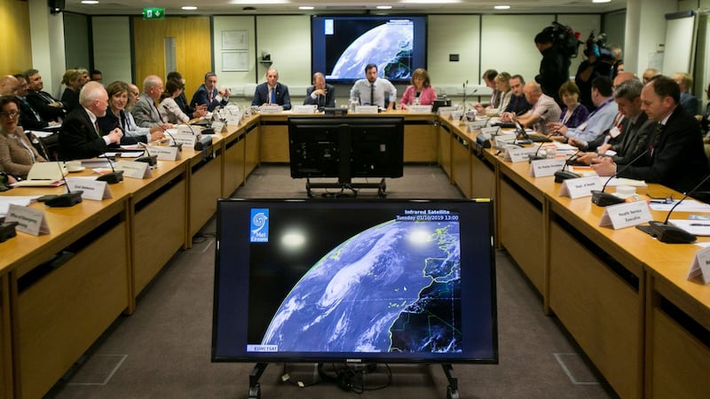
Emergency group meeting
The National Emergency Coordination Group (NECG) held a meeting chaired by Minister for Planning Eoghan Murphy on Tuesday. The group will meet again on Wednesday.
“Our primary concern is around coastal areas, very significant storm wave surges that we are going to see around coastal areas. They will be quite ferocious , very dangerous,” Mr Murphy told RTÉ.
He said a secondary concern was very strong winds at a time when trees were full of leaves. During Storm Ophelia in 2017 when trees were full of leaves and were felled by high winds there were cuts to power lines and flooding.
Minister for Defence Paul Kehoe and Minister of State for Housing Damien English were also in attendance at Tuesday’s meeting of the NECG.
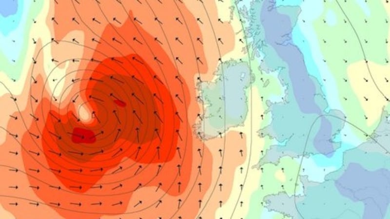
Current Met Éireann forecasts indicate that Storm Lorenzo will move across the country during Thursday night into Friday morning, moving west to east.
Local authorities, which are the lead agencies for the response to severe weather, have activated their crisis management teams and local coordination groups in preparation for the arrival of Storm Lorenzo. The HSE and Irish Water have done likewise.
The NECG said the Department of Transport has also activated crisis weather plans, with Transport Infrastructure Ireland crews "ready and on standby" to deal with any potential difficulties posed by the storm.
It also said the Department of Employment Affairs and Social Protection is on standby with community welfare officers ready to assist with damage and recovery due to the impacts of the storm.
The Department of Housing has put preparations in place and is in contact with all local authorities and are providing additional beds in outreach centres for rough sleepers.
ESB Networks said it was ready to mobilise responses to restore power once the impact of the storm is known. The powercheck app will enable users to gather updates on estimated restoration times. Safety regarding fallen lines will be communicated also.
Defence Forces troops are “on standby” too and available to assist in the response if and when required. Civil Defence personnel are also on standby to assist if needed.
High seas
The NECG said more detailed public safety messaging will be issued on Wednesday morning and throughout Wednesday and Thursday. People are advised to monitor news and other local sources of information.
It is likely there will be high seas and the public is advised to stay away from coastal areas during this period.
Very strong winds are predicted which will make driving conditions hazardous, especially for the more vulnerable road users, such as cyclists, pedestrians, motorcyclists and high sided vehicles.
Road users should pay particular attention to the risk posed by fallen trees and flying debris as trees are in full leaf.
The public was again reminded to monitor Met Éireann forecasts for their area and to be aware of the weather conditions and to heed safety warnings. Information is available across social media platforms and other traditional media sources.
The National Emergency Coordination Group is monitoring the situation and will meet again on Wednesday at 10.30am to review the developing situation.
There were delays of up to 25 minutes to Dart services earlier on Tuesday as water coming over the sea wall at Seapoint in south Dublin affected signalling. The issue has been resolved and currently the delays are about 15minutes.
Meanwhile, the threat of the hurricane has led the Union of Students in Ireland to cancel a national demonstration planned for Thursday that was designed to “break the barriers to higher education”.


