
Over the years, like thousands of others I have climbed every peak in the Macgillycuddy Reeks. But many of us have neglected Screig Bheag (573m) which lies to the north of Screig Mhór (848m). This is a major peak on the Coomloughra Horseshoe and is one of the best ridge walks in these islands.
Going clockwise around is not an attractive proposition because it will divert you from attaining the top of the ridge in good time. If you go anti-clockwise around, you are too tired to make the diversion. After many years a solution – that should have been screamingly obvious if we were not constantly seduced by the high peaks and ridges – dawned on me. Why not make a route that encompasses just the two Screigs which would be a good outing on a winter’s day?
The route starts from the base of “The Dam Track” up to Lough Eighter, with its all-embracing view of Coomloughra a sight that never ceases to enthrall me. It is a steep but straightforward pull up to Cnoc Íochtair (747m) with the view enhanced all the while as the surface of the inner lakes of the com come into view. From here it is a straightforward trek across the ridge to the boulder-bedecked summit of Screig Mhór. It seems strange not to be heading on east but turning north to drop down to the col that separates the two Screigs.
Reaching the bottom of Screig Bheag, I had a most pleasant surprise. In many upland areas of the country, heather is no longer burnt off owing to the proximity of forestry plantations. This has an inimical effect on wildlife as mountain birds will not nest in long leggy heather. Hill walkers are not gruntled by it either as it makes trudging up through it a drudgery.
Not being in the vicinity of such vegetation, Screig Bheag was burnt off some years ago. The result has been the regrowth of a lush carpet of Bell and Ling Heather such as I have not seen for many a year.
I sat on a rock in the middle of this purple and white vibrant mosaic to study the fresh perspective which this neglected summit gives of the northern slopes of the Reeks, stretching all the way over to Lough Leane. There was also a fine view of the upper reaches of Dingle Bay; more comprehensive than that from the higher peaks to the south.
The descent was an easy drop down to a remarkable example of a lateral moraine, which is a long mound of material formed by rock and soil falling between the mountain and the glacier moving along the valley. A walk along the top of this classic glacial landform brings you on to the Dam Track and the bitter trek down its steep stony slope to the car park.
The term “scrag-end” came into my head as I descended the stony track. More common in my youth, it is the inferior end of a neck of mutton and was much in demand because of its cheapness.
The “Screig-End” of the Reeks is certainly not inferior.
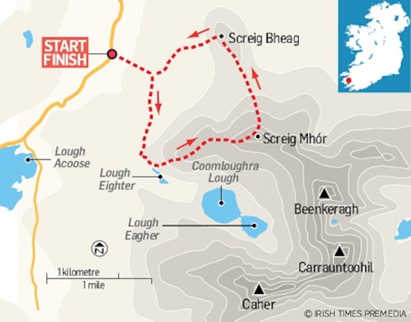
Screig Mhór & Screig Bheag, Co Kerry
Start & Finish: At the new car park at the foot of "The Dam Track" Grid Reference: V 772 872
How to get there: Take the N72 west from Killarney for 5km. Turn left on to the Gap of Dunloe / Glencar Third Class Road. Continue on the Glencar Road around the foot of the Reeks for 16 Km. The car park is sign-posted.
Time: Five hours
Distance: 8km
Ascent: 800m
Suitability: Route is Moderate. Rain Gear, Boots, Gaiters, Compass & Map essential
Food & Accommodation: Glencar, Killorglin, Killarney


