
Over the years, it’s been inevitable that many of Dublin’s streets and lanes have disappeared, in the name of progress.
But in recent decades, the largest-scale demolition of streets came when the Ilac Centre was being built. The land in the area had been acquired by the old Dublin Corporation over many years and its plans for redeveloping the site culminated in the construction of the Ilac centre, which opened in 1981. Around a dozen streets and lanes were demolished, including Coles Lane and Riddal’s Row. One of the streets torn down was Little Denmark Street, where 2RN, the predecessor of RTÉ, began broadcasting in 1926. Four markets were wiped out, the Anglesea Market, famous for its second-hand clothes, shoes and furniture; the Norfolk Market; the Rotunda Market; and Taaffe’s Market.
Today, only part of Chapel Lane and a little of Sampson’s Lane remain, in severely truncated form, as a reminder of what once stood there.
When the other two Dublin city centre shopping centres were built subsequently, the Jervis Centre and the St Stephen’s Green shopping centre, there was no big destruction of streetscapes. But building the St Stephen’s Green centre entailed pulling down the Dandelion market off South King Street (where U2 played one of their first gigs), May’s music shop, the Green cinema and Rice’s pub.
Long before anyone had thought of shopping centres, when Busáras was built, probably the most controversial new building ever constructed in Ireland, the streetscape around it was much altered to make the new bus station an island site. It opened in 1953.
The present Wood Quay bears no resemblance to what existed before the 1980s, when it had one of the most important Viking sites in Europe
Much earlier than that, on the north side of the river Liffey, Oxmanton Green was a vast area of common pasturage that stretched from Blackhall Place as far as the Phoenix Park. It was much developed in the 17th and 18th centuries and part of it was given over to what has been the headquarters of the Law Society of Ireland in Blackhall Place since 1978. Today, there’s nothing to be seen of this once vast green area.
Coming back to the city centre, Exchequer Street is one of the oldest streets in Dublin, going back to the 12th century, and until the late 18th century often called simply Chequer Street. It once ran from George’s Street to Grafton Street. The way in which the street was used over the centuries changed dramatically; in the 18th century, it was notorious for its multitude of brothels, while in the 20th century it became the site of a telephone exchange. In the course of all these changes, many of the lanes off Exchequer Street were wiped off the map, including King’s Head Court, Pennett’s Lane and Trinity Place.
Elsewhere in the city centre, many other streets and lanes disappeared. High Street once had three lanes, each called Ram’s Lane; all have long since vanished. Canon Street, off Bride Street, was once the city’s shortest street, with one building, Rutledge’s pub. When Bride Street was widened in the early 1960s, the pub and the street vanished.
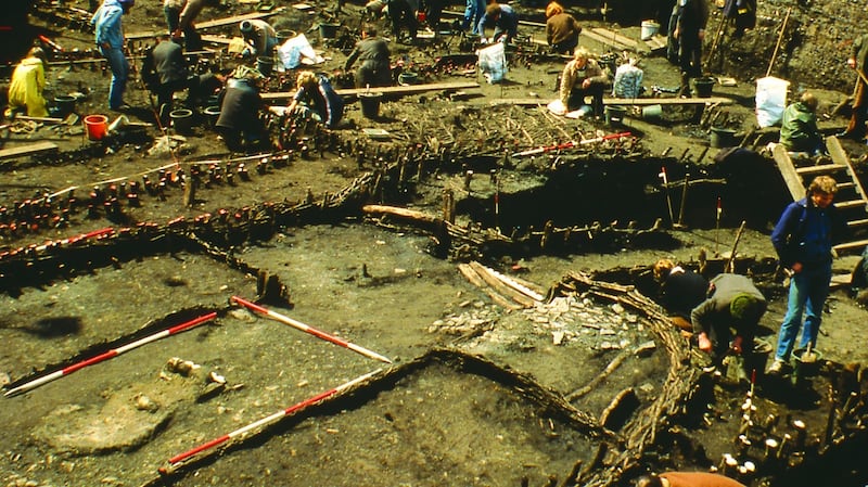
The present Wood Quay bears no resemblance to what existed before the 1980s, when it had one of the most important Viking sites in Europe.
Close to the Grand Canal, Northumberland Street was a short-lived thoroughfare in the 19th century that linked Charlemont Street with Upper Leeson Street. Today, the only stretch of what was once Northumberland Street is that very short stretch of street where Upper Leeson Street swings round into Sussex Road, renowned for places like O’Brien’s pub and the Canal Bank café.
In the 1980s, a short street at Kelly’s Corner called Charlotte Street disappeared, to make way for a hotel and a big office block. The street officially ceased to exist in 1992. Fortunately, the Bleeding Horse pub survived this change.
Change is inevitable as the city progresses, but fortunately we've managed to hang on to most of our main streets
It was the same story in the suburbs. Mount Brown lost its Cutthroat Lane, and Murdering Lane too, while in more recent times, Inchicore lost Keogh Square in the late 1960s.
In Stillorgan, the village was bypassed and today, you can still see the turn into what is now the Old Dublin Road, close to Oatlands College; this sharp bend was once a bend on the old Stillorgan Road. The most recent loss of a thoroughfare in the city centre has been the Leinster Market, a pedestrian-paved passageway, once well kept, that is now barred to the public and is filled with waste bins and rubbish. It ran from D’Olier Street to Hawkins Street. It used to open out onto that once great centre of entertainment, the old Theatre Royal. As long ago as 1861, the Leinster Market had been described as a “quaint, narrow passage with very little light, even in its open parts”.
Change is inevitable as the city progresses, but fortunately we’ve managed to hang on to most of our main streets.


