When the weather is good, there is so much to do outdoors in Ireland – solo, or with family or friends. Here are seven activities - with locations, descriptions, tips and some maps for a general guide.
Below you can read John O'Dwyer's pick for a great walking path, Conor O'Keeffe on a running route, Rozanna Purcell recommends a hiking trail, Mary McCarthy on an outdoor swimming location, Ian O'Riordan picks a cycle trip, Sylvia Thompson on a family-friendly park and Fiona Alston selects a popular outdoor gym.
And remember, whatever you do and wherever you go, please be safe. And enjoy.
Name Red Trail
Location Scaragh Wood is located just outside Cahir town.
Distance 6km loop
Approximate duration 2 hours
Difficulty Moderate, with one strenuous section
Starting point Google Maps Scaragh Wood car park (grid reference S 028 049); you can follow this Munster Vales guide
Amenities Parking
Lovely new trail that rises through mixed woodland above the town of Cahir to gain open mountainside. Here there are splendid views to the Knockmealdown and Comeragh Mountains.
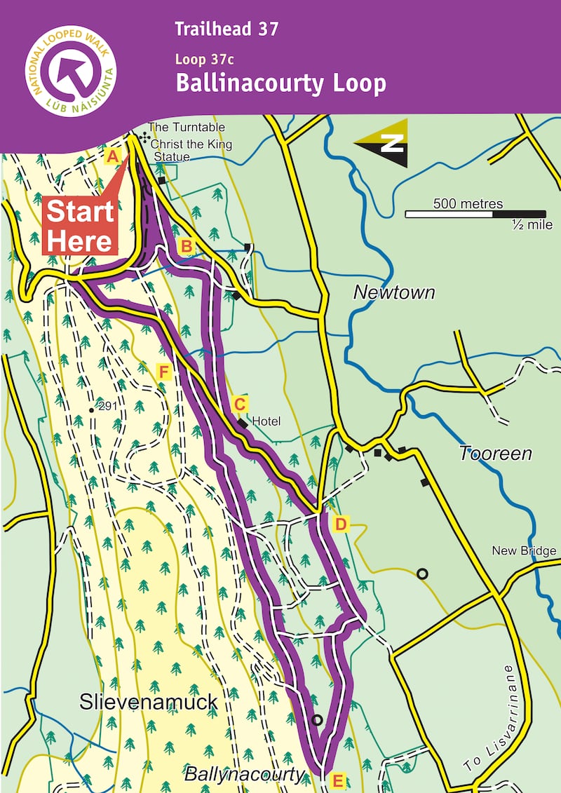
Name: Glen of Aherlow – Ballinacourty loop
Grade: Moderate
Length: 6km
Format: Loop
Ascent: 240m
Dogs Allowed: Yes
Footwear: Road or Trail Runners
Waymarking: Purple arrow on yellow background
Start/Finish Point: Christ the King statue, Glen of Aherlow
Nearest Town to Start: Lisvarrinane
Route information: From the mapboard in the green area at Christ the King statue follow downhill to enter the Nature Park. This loop is marked with purple arrows – but overlaps with two other loops (green and light blue arrows) and the long-distance Ballyhoura Way which is marked with the familiar yellow walking man and arrows. Descend wooden steps and over a footbridge and shortly afterwards you reach a Y-junction. Veer left here and follow the woodland trail for approximately 1km to reach a wooden stile. Exiting the stile the green loop turns right – you turn left.
You are now on a more substantial forestry track. Descend for 300m to reach a four-track junction where you turn right and follow a forestry track for 800m to exit at a surfaced road just uphill from the Aherlow House Hotel. Here you leave the light blue loop and turn downhill following the yellow Ballyhoura Way. Pass the hotel and follow the tarred surface downhill to reach a sharp left bend where you turn right and enter forestry again. Continue to follow the Ballyhoura Way along forestry tracks for a flat section before turning right and ascending through Ballynacourty Woods. After 1.5km you reach a T-junction where the Ballyhoura Way turns left and you overlap with other loops that start and finish in the village of Lisvarrinane. You turn right here to begin the homeward journey.
For more than 2km the loop traverses the southern shoulder of Slievenamuck Mountain and rejoins the light blue loop above the Aherlow House Hotel before joining a tarred roadway. Here you veer left. Follow the tarred roadway for a short distance before turning right into forestry again. Following woodland trails, you pick up the green loop at a small stile, and after 1km reach a three-way junction where you rejoin the outward route. Veer left and retrace your steps for 300m to regain the trailhead. (Aided by: Coillte)
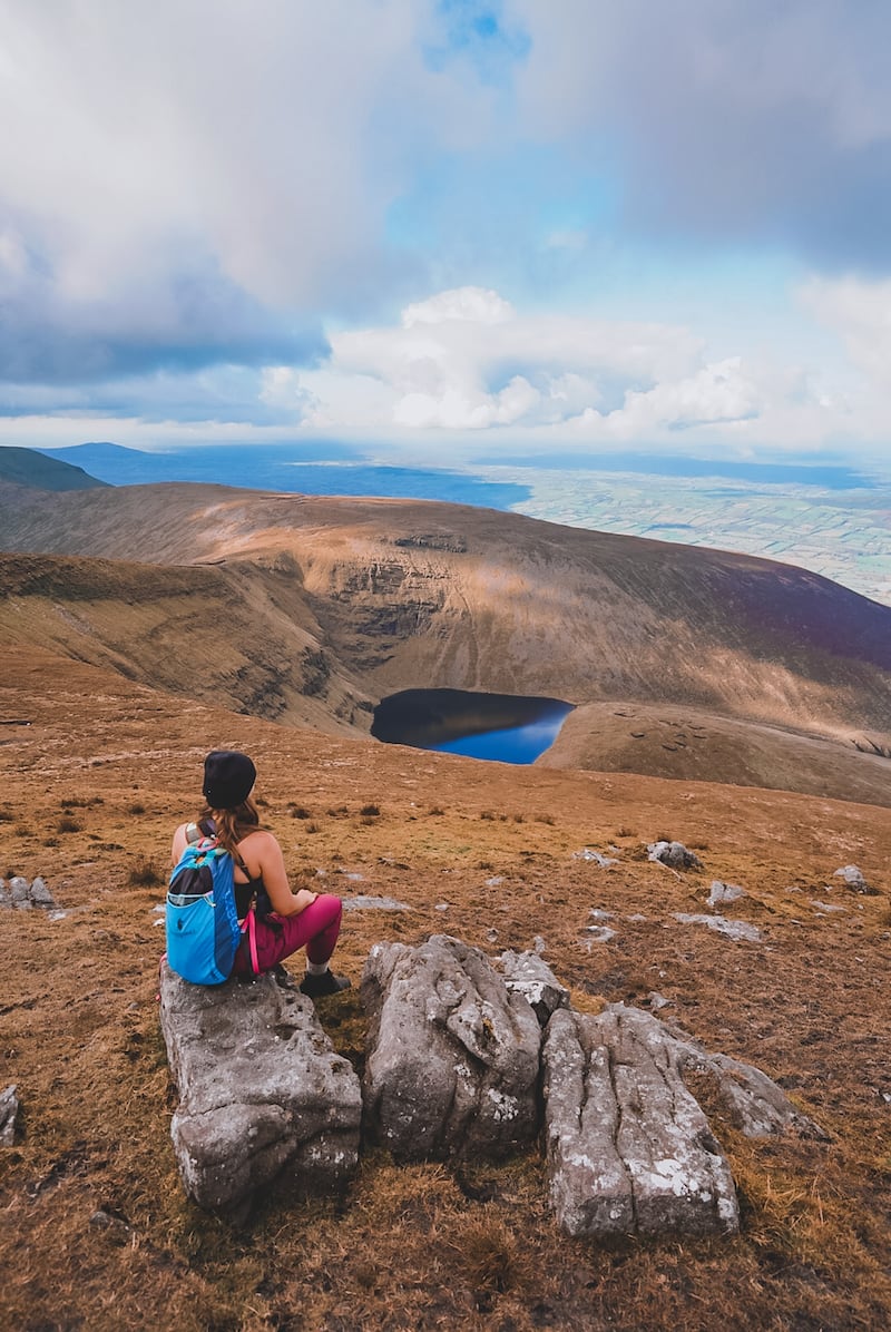
Hike name Galtymore
Distance 10.7km
Elevation gain 815m
Approximate duration 3-3.5 hours
Difficulty Intermediate
Route type Out and back
Starting point See AllTrails Galtymore
Amenities Toilets, limited parking
Dog-friendly? No dogs
Tips Keep an eye on the white painted stones for a good marker on the route up
Name: Lough Derg
Location: Google Map: Lough Derg, Hasseys pier, Dromineer
Brief description: Small beach east side of Lough Derg. Bottom is sandy. Slope very gradual and 2.5m end of pier
Amenities: Parking, public toilets and showers
Lifeguard: No but has Royal National Lifeboat Institution (RNLI) station
Water quality: Good. EPA test regularly
Tips: Water can be rough in extreme conditions. It's the third biggest lake with its own weather system. Swim between the two piers in Dromineer and head for the famous coffee cake after at the Lake cafe open March-Oct and weekends low season
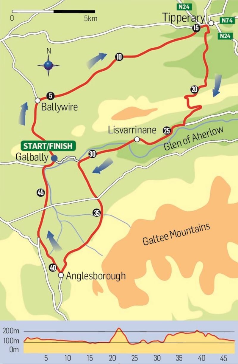
Name: Glen of Aherlow Circuit
Start location: Tipperary Town
Route: From Tipperary town, a gently sweeping climb through Bansha Woods into the Glen of Aherlow, on towards the village of Anglesborough, and back down via Galbally by briefly passing into Limerick
Distance: 47km
Time: 2.5 to 3 hours.
Highlights: The majestic looking Galtee Mountains as the backdrop into Aherlow
Look out for: The Aherlow House Hotel, the prefect coffee stop.
Tips: The Glen itself is relatively quiet of traffic, though pretty steep in parts too.
Park name: Castlelough Lakeside Park, Portroe
Amenities: The designated recreation areas of the Arra forest on the shores of Lough Derg. Walking trails along Lough Derg, water skiing, paddleboarding, canoeing, fishing and cruises along the River Shannon.
Special features: Those keen for longer walks can consider doing stages of the Lough Derg Way which passes through Castlelough.
Access: Car park on site. Google Map "Castlelough Park".
Dogs: Dogs on leads are welcome.
Tip: Plan water activities in advance and don't forget your wetsuits.
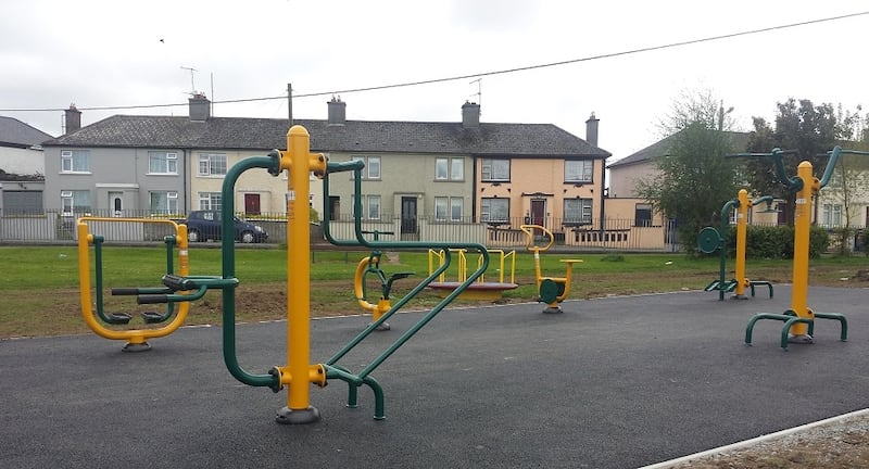
Name: Loughtagalla Park, Thurles, Co Tipperary
Equipment: Fitness rider, walker, bicycle, ab curl, back massager, chin-up bars, dip bars, body twist (wheelchair), arm strength (wheelchair).
Location: Google Maps
Information: There are plans for a biodiversity park and sensory garden to be added to this space.