

When the weather is good, there is so much to do outdoors in Ireland – solo, or with family or friends. Here are seven activities - with locations, descriptions, tips and some maps for a general guide.
Below you can read John O'Dwyer's pick for a great walking path, Conor O'Keeffe on a running route, Rozanna Purcell recommends a hiking trail, Mary McCarthy on an outdoor swimming location, Ian O'Riordan picks a cycle trip, Sylvia Thompson on a family-friendly park and Fiona Alston selects a popular outdoor gym.
And remember, whatever you do and wherever you go, please be safe. And enjoy.
Name Foxboro Trail
Distance 4km loop
Approximate duration 1 hour
Difficulty Moderate
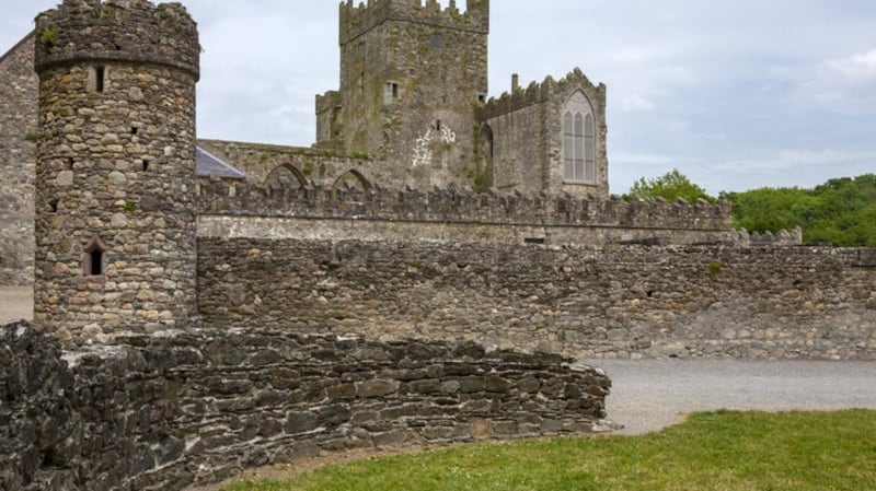
Starting point Google Maps Tintern Abbey (grid reference S 795 101); you can follow this Sport Ireland guide
Amenities Parking and tea rooms
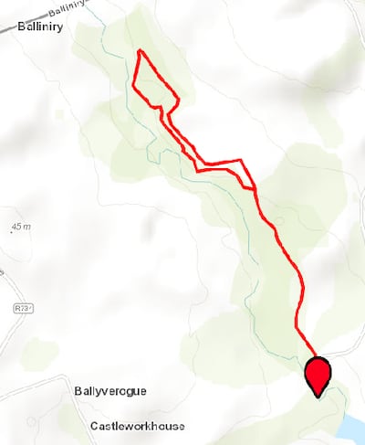
White arrows lead from the Abbey and then tag the Tintern River through a tranquil deciduous forest. Some climbs involved on uneven ground, so sturdy footwear is recommended.
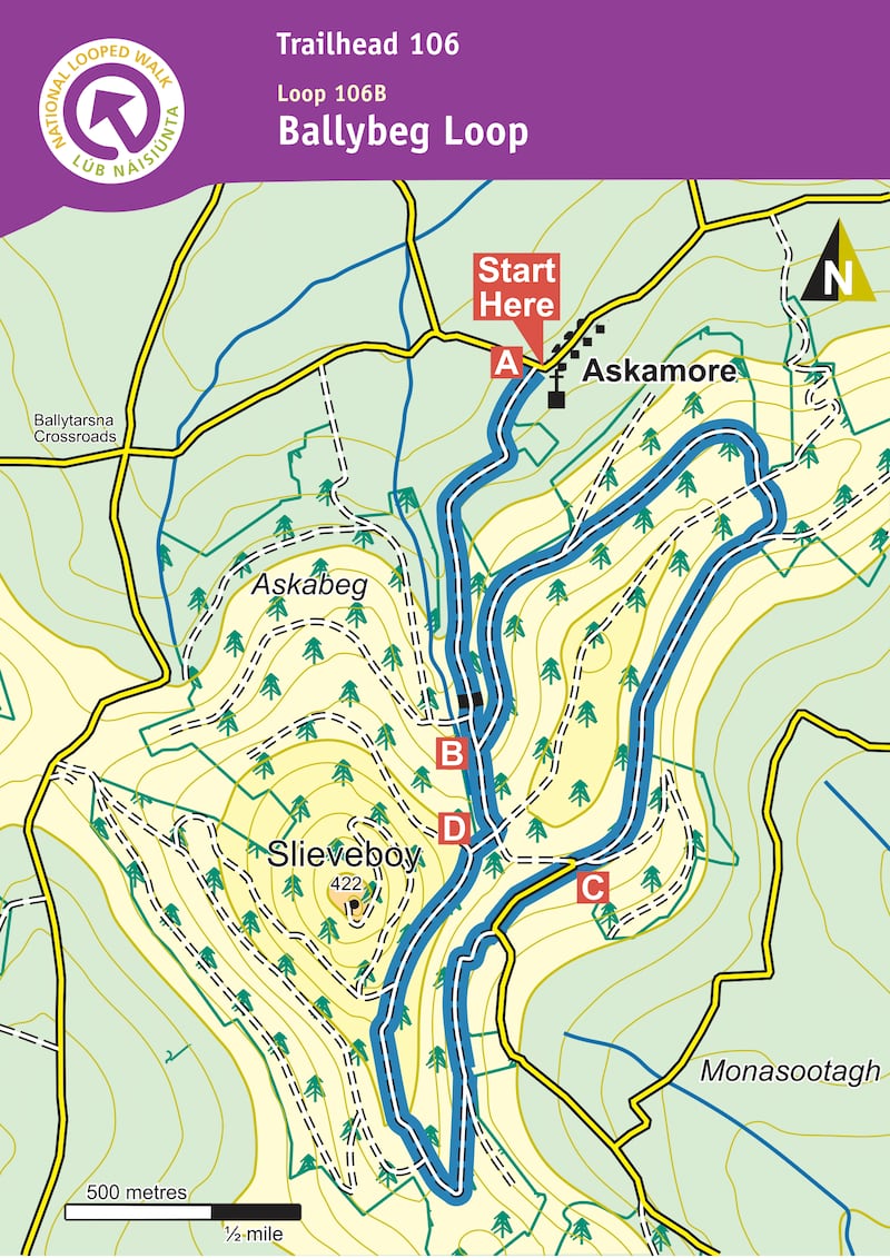
Name: Ballybeg Loop
Background: This loop follows blue arrows in a clockwise loop through Askamore Forest, on sandy lane, forest road, forest track and tarred road. It climbs and descends steadily on the access lane to the loop while the loop itself is more-or-less level, apart from a gradual ascent towards the southern end and an ascent and descent along the slopes of Slieveboy. There are some fine views of the surrounding countryside.
Route information: From the trailhead cross the road and follow the blue (and green and purple) arrows onto the sandy lane between the church and Doran's pub. The green arrows are for the shorter Askamore Loop, the purple arrows are for the longer Slieveboy Loop. Continue along the sandy lane for more than 1km to a junction with a forestry road on your left. The loop proper begins here – you will return to this point from the opposite direction later – for now, turn left. Continue to follow the blue (and green and purple) arrows along the forestry road for 3km – enjoying some fine views of the surrounding countryside as you go – before rejoining the sandy lane at what is known locally as the "hairpin". The green loop veers right here – you veer left following the blue (and purple) arrows.
Follow the surfaced roadway downhill for 200m to a sharp left bend – and veer right onto a narrow forestry track. Continue to follow this track as it ascends over the next 500m to reach a 3-way junction where the purple loop turns left – but you continue straight ahead. After 300m you pass a junction where the purple loop rejoins from your left – continue straight and after 300m you exit forestry and rejoin the sandy lane you started out on. Turn left and downhill. After only 200m you reach the junction at B above from where you began the loop. This time proceed straight ahead and enjoy the 1km back to the trailhead. (Aided by: Sport Ireland and Coillte)
Hike name Blackstairs Trek
Distance 10.9km
Elevation gain 580m
Approximate duration 3 hours
Difficulty Intermediate
Route type Out and back
Starting point See AllTrails Blackstairs Trek
Amenities No parking, just some space at forest gate
Dog-friendly? No
Tips Get there early for a space to park
Name: Carne beach
Location: Google Map: Carne Beach
Brief description: Blue Flag, fine sand underfoot
Amenities: Toilets, car park
Lifeguard: Summer
Water quality: Excellent – Wexford County Council sampled September 2020
Tips: Ideal for families as water is quite shallow. Very romantic for a sunrise/sunset swim.
Name: Ring of Hook Head
Start location: Duncannon
Route: Another recommendation from Turlough O'Brien, setting off from the seaside village of Duncannon, heading south via Templetown out towards Hook Lighthouse, then returning via Fethard and Saltmills and Tintern Abbey.
Distance: 44km
Time: 2-3 hours
Highlights: A route full of history and mystery with sweet scenery to boot.
Look out for: Loftus Hall, Ireland's most haunted house, on the way into Hook Head.
Tips: Pause to enjoy some of the iconic sights topped off by Hook Lighthouse.

Park name: Irish National Heritage Park, Wexford Town
Amenities: A chance to explore 9000 years of Irish history through replicas of a castle, crannóg, Viking house, monastery and ringfort. Also walks through woodlands and two playgrounds.
Special features: Activity-based experiences such as archery, medieval cooking and interactions with birds of prey at the falconry centre.
Access: car parking on site and buses from Wexford town. Adult €11, child €6, irishheritage.ie. Google Map "Irish National Heritage Park".
Dogs: Only guide and assistance dogs allowed.
Tip: Give yourself plenty of time to see everything on a self-guided tour or join a tour with a costumed guide.
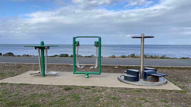
Name: Gorey Town Park
Equipment: Hip twister, shoulder flexor and a multistation.
Location: Google Maps
Information: There are also a walking trail and a skate park at this location.
Get Active Series
- 32 great walking routes in Ireland - one in each county
- 32 great hikes in Ireland
- 32 great running routes
- 32 great outdoor swim locations
- 32 great cycling routes
- 32 great parks
- 32 great outdoor gyms


