Please remember the maps below are just a guide and whenever and wherever you go, stay safe.
Antrim
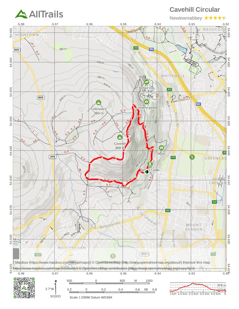
Name: Cavehill Trail
Length: 5.1km
Elevation gain: 271m
Route type: Loop
Footwear: Road or Trail Runners
Dogs: Permitted, but dogs must be kept on a lead.
Route Information: This is a challenging circular route ran anti-clockwise beginning at Belfast Castle and following the green way marked arrows. It can, however, be joined from Bellevue car park, Upper Hightown Road or Upper Cavehill Road. Begin at the interpretative panel in the car park just before the entrance to Belfast Castle. Climb up the path on your left until you reach the first junction. Turn right and follow this path through the woodland, keeping to the left of any of the junctions you come to. This path leads up through the trees, climbing on to an open seating area. If you would like a breather, stop here and admire the fabulous views over the city and Belfast Lough. Continuing on, you will arrive at the Devil's Punchbowl with the first cave facing you. Keep on the path to the right of that cave and you will skirt the plateau on an easy ascent. The path will then left onto the cliff top at the junction with Hazelwood. Continue gently climb the plateau towards McArts Fort. This affords some magnificent views. The trail will continue on a pretty wide gravel path heading southward with views over the beautiful Lagan Valley. Follow this towards the Upper Hightown Road. Along the way on the left you will pass a path which provides a short cut past the limestone quarry in case you are feeling too fatigued and need to shorten the route. At the bottom of these steps turn right and join the main castle drive. Continuing on the Cavehill trail turn left at the dogleg near the waterfall and follow the lane along the perimeter. This will take you to the Upper Cavehill Road entrance, re-enter the site using the entrance on the left and follow the path into the woodland. At the junction take the path on the right and you will return to the main drive to Belfast Castle. Follow this to back to the walking trailhead.
Facilities: Belfast Castle is open to the public. A restaurant in the basement offers a variety of menus from morning coffee to full meals. Pop in and fuel up after your run with plenty of carbs and caffeine! The second floor of the Castle plays host to the Cave Hill Visitor Centre with exciting displays on the history, folklore, wildlife and geology of Cave Hill Country park and the story of Belfast Castle.
The following facilities are available for users with limited mobility:
- Cafe (wheelchair accessible) – 12pm-3pm, Monday-Saturday.
- Disabled toilets
- Disabled parking
Aided by: Trek NI
Armagh
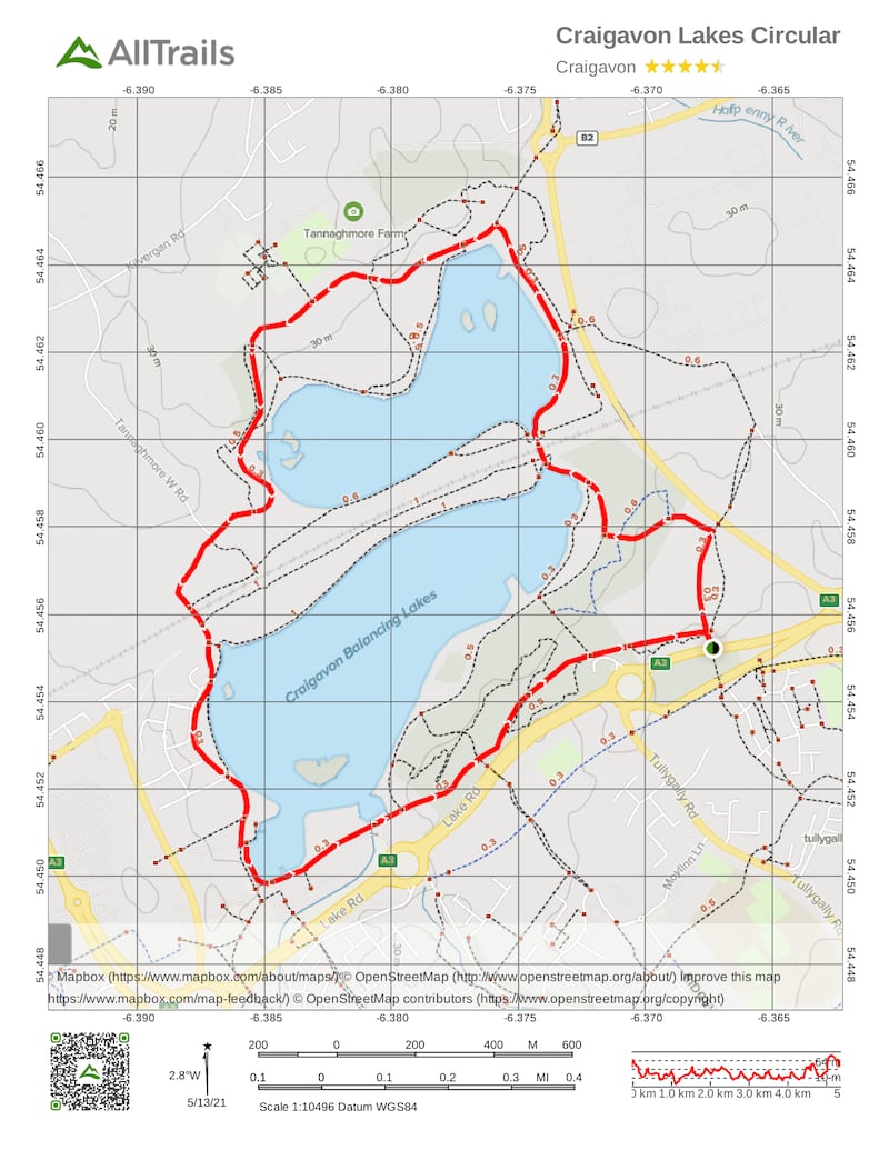
Name: Craigavon Lakes
Length: 5km
Route type: Loop
Footwear: Road or Trail Runners
Terrain: Varied
Amenities: Toilets and refreshments are available from the Craigavon Watersports Centre and Tannaghmore Animal Farm.
The following facilities are available for users with limited mobility:
- Disabled toilets
- Disabled parking
Route Information: From the Craigavon Watersports Centre car park, start walking on the wide tarmac path beside the lake and walk in either a clockwise or anti-clockwise direction, keeping the lake to one side. For the first half of the walk, follow the signs for Tannaghmore Gardens. Once you have reached the gardens, follow the signs for Craigavon Water Sports Centre to return to the car park. During the walk, you will come to two bridges. You must pass under these in order to complete the circuit of both lakes. It will take approximately 45 mins to 1 hour to complete the walk and at one point you may be up to 100 metres from the water's edge. When you approach the railway line, you may want to take a short detour into the Local Nature Reserve on either side of the railway line, to view the wildflowers, butterflies and orchids, however it should be noted that the path for this walk has yet to be laid and is therefore currently unsuitable for disabled users and pushchairs. (Aided by: Trek NI)
Carlow
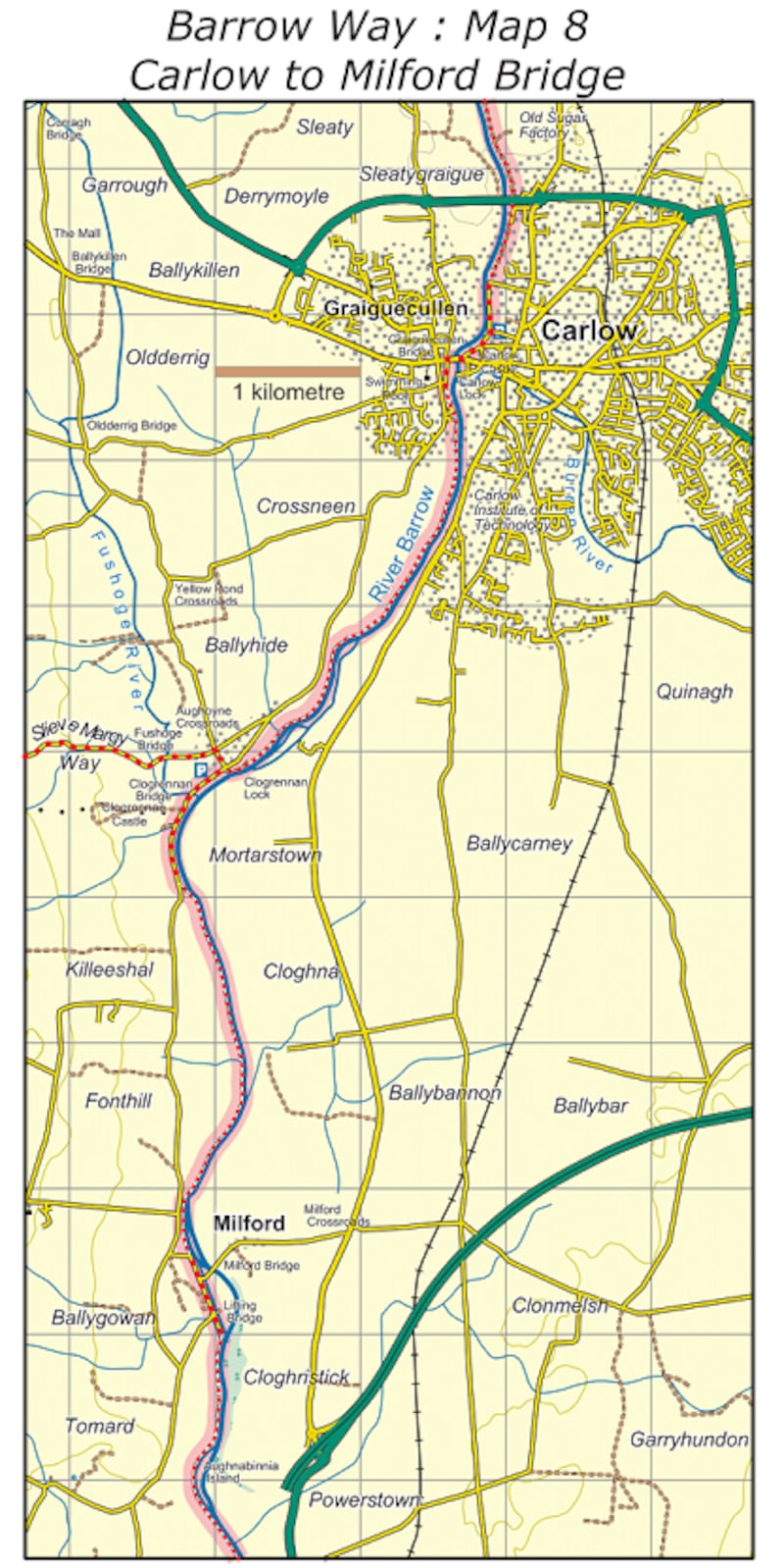
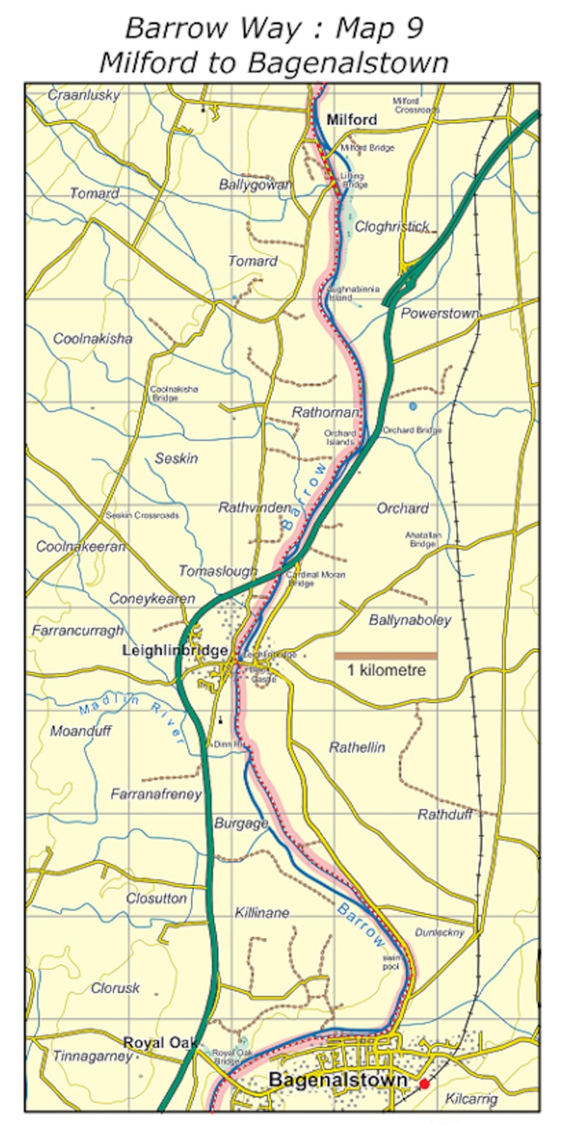
Name: The Barrow Way: Carlow-Bagenalstown
Length: 18km
Grade: Easy
Terrain: Road, track and River Towpath
Route type: Loop
Footwear: Road or Trail Runners
Dogs: Dogs are permitted, dogs must be kept on a lead.
Type of trail: National Way Marked Trail – yellow arrow on black background.
Route Information: From Carlow the Barrow Way switches to the right or west bank of the River Barrow at Wellington or Graiguecullen Bridge. The 13th century Carlow Castle which protected the river crossing and around which Carlow town developed, is well worth a visit. The landscape changes south of Carlow town, flat plains are replaced by hills on either side with wooded valleys. The Castlecomer Plateau rises up on the west side. Below Carlow, the ruins of Clogrennan Castle and Clogrennan House, seat of the Rochforts can be seen on the right or west bank. Milford is a pleasant spot on the River Barrow and is particularly rich in plant and bird life – spot the herons, kingfishers and swallows among the many species of birds. The ruins of Milford Mill (1790-1965), established by the Alexander family are nearby and were once the site of a busy flour, malting and tannery business. In the 1890s the present day mill was used as a generating station for electricity with Carlow the first inland town in Ireland and the UK to have electric street lighting. Leighlinbridge is another old town built on a crossing point which was guarded by the Black Castle. The bridge at Leighlinbridge, built in 1320, is the oldest on the River Barrow. The Way now switches to the left bank and as you leave the village behind, the ancient site of Dinn Righ lies up on your right, said to be a fort of one of the former Kings of Leinster. Bagenalstown is reached shortly after passing the outdoor swimming pool. In modern times the village has won numerous awards in the Tidy Towns competition. (Aided by: Carlow Tourism)
Cavan
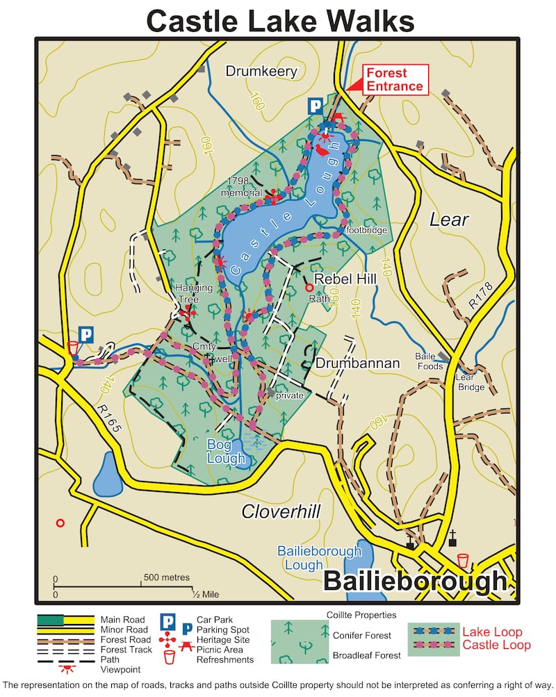
Name: Castle Lake Loop – Bailieborough
Length: 6.5km
Grade: Easy
Route type: Loop
Footwear: Road or Trail Runners
Dogs: Dogs are permitted, dogs must be kept on a lead.
Background: The Irish language translation of Bailieborough is Coill an Chollaigh, meaning forest of the boar. Today, you are not going to encounter any boars in this small County Cavan town, well known for its proximity to lakes and forests. Nor indeed, will you meet any in Castle Lake forestry, where this loop has been developed.
Route Information: The loop begins and ends at the car park on the lakeshore and takes you around Castle Lake, with some stunning views and interesting sites along the way, including a memorial to those who died at Rebel Hill in 1798. The longer loop (an additional 3 kilometres) takes you by the graves of the Marist brothers who occupied Bailieborough Castle. The castle (the remains of which are also to be seen in the forest) was built by William Bailie, a Scottish undertaker or planter, who was granted the lands of Tandragee in east Breffni by King James I. He built the castle and enclosed the demesne by 1629.
Start from the car park at Castle Lake. Facing the lake, start through the barrier on your right. Follow the blue arrows along a forestry road on the southern end of the lake. After a kilometre, veer left at a Y-junction and continue for another kilometre to reach a crossroads. Turn left here. After 100 metres turn sharp left at another crossroads. Climbing gently now, the loop soon affords you spectacular views over Castle Lake and the surrounding countryside. Descending again you reach a wooden footbridge which takes you across a river. Shortly after crossing the footbridge the loop rejoins the lakeshore, the trailhead is only 600 metres away. (Aided by: This Is Cavan)
Clare
Name: O'Briensbridge – Old Barge Loop
Length: 11.4km
Elevation gain: 292m
Route type: Loop
Footwear: Road Runners
Background: The village of O'Briensbridge stands on the eastern verge of Co Clare, on the bank of the river Shannon – the longest river in Ireland. The bridge which gives its name to the village stands across the Shannon, and has at its east end, in Co. Limerick, the village of Montpelier. The section of the river downstream from O'Briensbridge is noted for angling and watersports. Upstream at Parteen the flow of the Shannon is diverted into a man-made canal (called the Shannon Headrace) for a hydroelectric station at Ardnacrusha. The Errinagh Canal was built to allow navigation of boats and barges to the city of Limerick. Today, the canal is being developed as a recreational amenity (fishing, watersports, etc) – the loop uses what was the towpath for horses as they pulled barges in previous times. This loop comprises the riverbank and towpaths from O'Briensbridge to Clonlara and returns via the headrace embankment.
Route Information: Starting from the riverside car park, follow the pathway along the River Shannon moving away from the village. Remember you are following the red arrows on the waymarkers but there are also blue arrows (for the shorter Errinagh Bridge Loop which you will leave) and the yellow arrows of the Lough Derg Way (a long-distance walking route which goes from Limerick City to Killaloe). You can use either of these route to either shorten or lengthen your run. Play around with the different routes and find the one that works for you best. This gives a lot of versatility to the area in terms of training. The pathway soon enters an area of beautiful natural woodland along the bank of the river this stunning scene was the old towpath. After about 1km the route veers right as you join the Errinagh Canal.
Continue to follow the canal bank to reach the Errinagh Bridge. Go under the bridge, and on your exit, climb the embankment and turn left following the red and yellow arrows. (Notice that the blue loop turns right at this point as it makes its way back to O'Briensbridge.) Take the blue route if you would like to shorten the run at this point. Follow the red and yellow arrows along a mix of towpath and sandy roadways. You will pass a canal lock on the way. At the end of this section you will join a tarred road where you turn right and, after 200m enter Clonlara Village. In the village, turn right onto a roadway. Follow the roadway onto the embankment of the Shannon Headrace and follow it for 5km (picking up the blue loop on the way) to exit via a stile at the end of forestry and onto a roadway. Continue straight here. After 300m enter the village again, turning right as you join the tarred road. Follow the road through the village – enjoying the 200m back to the trailhead. (Aided by: Coillte)

Cork
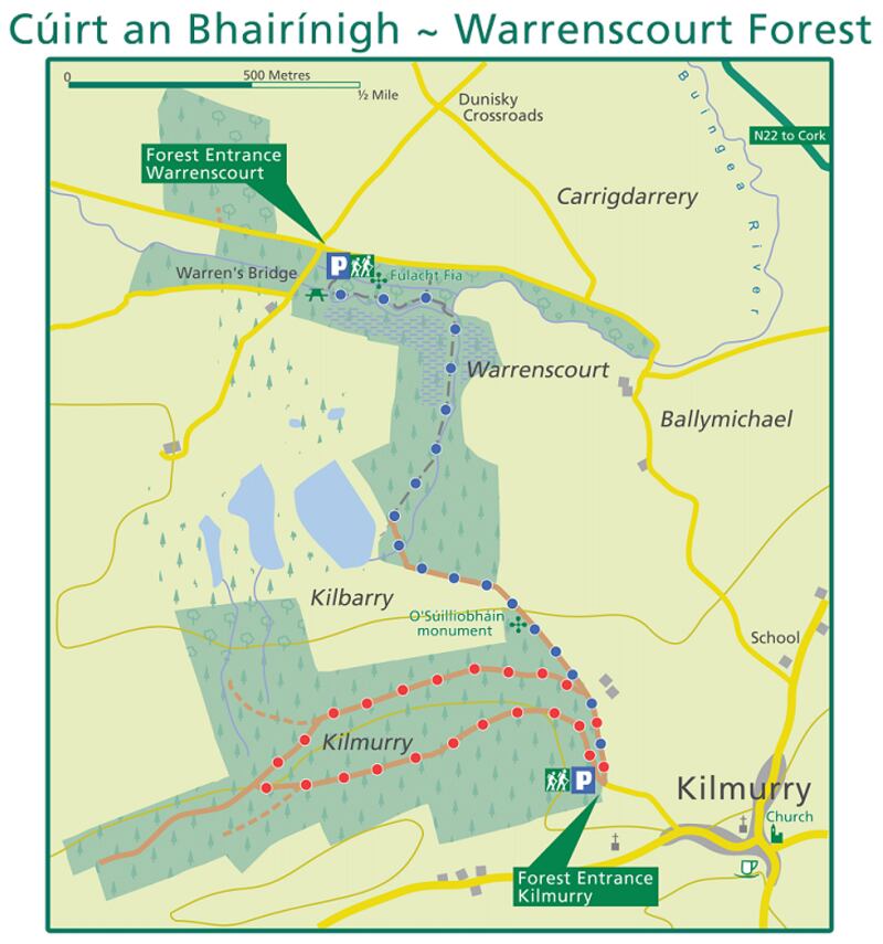
Name: Warrenscourt – Kilmurry
Length: 6.3 km
Elevation gain: 191 m
Route type: Loop
Background: Warrenscourt comprises some 110 hectares of gently sloping woodland overlooking the Buingea river and the rich farmland that surrounds it. The main feature is the trail that runs beside the river and the green area that is popular with young families. It is linked with another parking area and picnic site on the outskirts of Kilmurry village. Interesting to note that a section of the old Butter Road that was used by farmers to bring their butter to the Cork market, used to run through the forest and is still in use today. Views open and close in this forest depending on the forest cycle. At times, the Derrynasaggart and Boggeragh mountains are visible with clear views of the Paps, Mullaghanish, Mushera More and Mushera Beg.
Route Information: Starting from the Warrenscourt First Car Park you have many run options. From the car park and picnic area you can run along the Wood Link (Blue Trail), which turns around at the Kilmurry Forest Car Park. Along the Wood Link however, you will pass the O'Suilliobháin Monument on your right. Directly after the monument you will have a turn on your right for the Kilmurry Wood Loop (Red Trail). You will take your next left and head back towards the the Kilmurry car park. That will add 2.3km to you run before you head back on yourself on the Blue Wood Link Trail to make it back to the Warrenscourt Forest Car Park to make it a 6.3km route in total. (Aided by: Discover Ireland, Coillte and Sport Ireland)
Derry
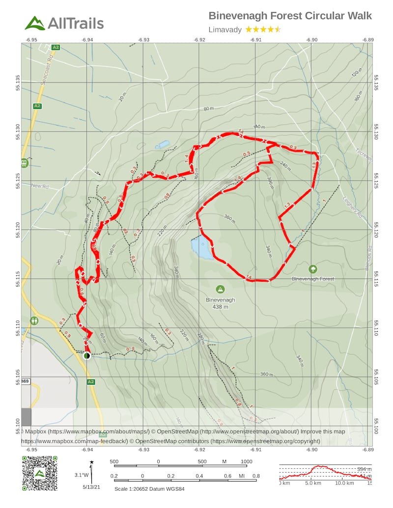
Name: Ballycarton Wood/Binevenagh trail
Length: 5km (10km out and back)
Terrain: Forest track
Route type: Linear (Out and Back)
Footwear: Road or Trail Runners
Getting to the start: By car is the easiest way to access the site. Follow the Causeway Coastal Route along Seacoast Road (B69) or the A2 from Limavady.
Traffic: May encounter Forest Service vehicles on route. Popular with walkers, other runners and orienteers/adventure racers.
Facilities: Nearest facilities for refreshments and toilets at Limavady town (8km).
Information for people with a disability: This route does not have accessible toilet facilities. Dusted forest track with steep gradients in places.
Background: A short linear route from Ballycarton Wood, along the forest track through Binevenagh Forest. Undulating track offers great views of the cliffs and glimpses of Lough Foyle, Magilligan and Benone Strand.
Route Information: Start from the car park at Ballycarton Wood off the A2 Aghanloo Road. Alternative start point at Swann's Bridge picnic site just off the Causeway Coastal Route. From Ballycarton Wood follow the path running adjacent to the A2 for a short distance before the trail starts to climb through the forest. The trail meanders as you travel north gaining height before it undulates along the foot of the mountain. The route is waymarked throughout the forest. After 2 miles (3.2km) the forest opens to your right revealing the cliff face of Binevenagh where you may see ravens, peregrines, buzzards or even gliders soaring above you. The entrance to the Nature Reserve is on your right (no cycling in the reserve, please!) The trail turns left at a right angle with a descent before swinging round and climbing eastwards as the the view opens up towards the North Coast. The trail finishes at the forest gate a short distance away where you can leave a car to return to the start or simply retrace your route back to Ballycarton. (Aided by: Trek NI)
Donegal
Name: Glenveagh – Lakeside Walk Glenveagh National Park,Churchill
Length: 3.5km (7km out and back)
Grade: Easy
Terrain: A mostly flat gravel path
Route type: Linear
Footwear: Road or Trail Runners
Background: This trail brings you through the glen from the visitor centre. It begins at the bus stop near the visitor centre to Glenveagh Castle and Gardens. The run begins at the bus shelter from where there is a wondrous view of the valley of Glenveagh and continues along the shores of Lough Veagh.
Route Information: The run starts through a stand of mature Austrian Pines and scattered native broadleaved trees such as holly, rowan and birch. See if you can identify each one (the app PlantNet will help you out here!). Past the wooden shingled roofed boathouse is a recently constructed bridge over the Owencarrow River. The bridge was constructed by park staff using seasoned larch and recycled plastic decking. Am I the only one who loves running over bridges? Thought not! The Owencarrow River is the main outflow from Lough Veagh which eventually meets the sea at the Lackagh Bridge near Doe Castle. The Owencarrow river is home to breeding salmon, trout, eel, freshwater pearl mussel, and otter. Keep and eye out for them as you run! Beyond the bridge the path takes runners out on to the more open landscape of blanket bog and wet heath habitat that is typical of much of Glenveagh and the west of Ireland generally. These wet peatlands may look quite barren with the lack of large tree life but they are home to an abundance of flora and fauna, many of which are unique to these types of habitat.
As the path meanders along the glen and lake side there are beautiful views across Lough Veagh and it's scattered islets to the cliffs and open hilltops beyond. Make sure you raise your head and look around from time to time to really allow the scenery to soak in. This sublime landscape offers a taste of a remote and peaceful Irish wilderness in all its raw beauty. Further along you will find examples of small native scrub woodland and the trickle of mountain streams. The path ends in the wonderful castle gardens, an amazing botanical contrast to the wilder surrounding landscape. Once you get there you can relax, take on some water and make your way back to the start for a lovely 7km run that'll get your blood pumping and fill your hungry eyes with beautiful natural West Coast scenes. (Aided by: Coillte)
Down
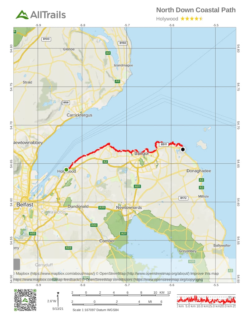
Name: North Down Coastal Path
Length: 25km
Terrain: Bitmac, Stone & Grass Paths
Nearest Town: Holywood, Co Down
Route type: Linear
Route Information: Beach, Coastal, Parkland & Grassland
Dogs: Dogs are allowed. Dogs must be kept under close control
Footwear: Road or Trail Runners
Route Information: The run begins at the Esplanade in Holywood. Head under the railway arch and turn right. Follow the linear path along the outer edge of Belfast Lough towards Seapark. This is a recreational area with a play park. (It may be a great place to take the kids on your rest day from running.) Continue past the park towards the Royal North Yacht Club. From here follow the public footpath as it rejoins the Coastal Path. At this point a detour to the right will lead to the Ulster Folk and Transport Museum and the railway halt. Continuing on the path leads to Craigavad, with the Royal Belfast Golf Club on your right. Beyond this point cross the bridge in front of Rockport Primary School. About 3km further round the coast, a set of steep steps takes you inland at the Seahill Sewage Treatment and rejoins the coast path as you descend at the far end.
Take some time to admire the views of the Irish Sea with some breathtaking coastal scenery. Feel the coastal breeze breathe life back into your legs as you meander through the North Down Coastal Path. From here the path leads to Crawfordsburn Country Park, passing Grey Point Fort, Helen's Bay and through to Crawfordsburn Beach. Grey Point Fort is one of the best preserved early 20th century coastal forts anywhere in the Ireland. Leaving the path briefly, cross Swineley Bay and pick up the path at the far side. If you need a break then on a sunny day stretch out on the sandy beach in the bay and take in some vitamin D. Continue walking along the path to Wilson's Point, where the path turns towards Bangor Marina.
From here follow the path round to Ballyholme Beach, which leads to the National Trust area of Ballymacormick Point. The path continues to Groomsport Harbour, where the path becomes rural in nature, crossing the beach area round towards Orlock Point, Portavo. A small lay-by indicates the end of the run. You can set up a collection point here or if there are two of you running, park one car at the end and one at the beginning.
Aided by: Trek NI
Dublin
Name:Carrickgollogan – Lead Mines Way – (Orange)
Route type: Loop
Grade: Easy
Length: 2km
Footwear: Road or Trail Runners
Background: Embrace impressive views over Dublin Bay, the city and the coast on this gentle 2km forest loop near Kilternan, County Dublin. An easy forest loop over woodland paths, the pleasant Carrickgollogan Lead Mines Way takes just 40 minutes to complete.
Route Information: This trail loops anticlockwise around lush Carrickgollogan forest, giving walkers the option of veering north to the disused 19th-century lead mines chimney or south to Carrickgollogan Hill. The historic lead mines chimney was in use until the 1920s, from this point you'll embrace views of Dublin City, pretty Dublin Bay and its recognisable coastline. The viewing rock atop Carrickgollogan Hill boasts more superb views, this time of verdant south Dublin and north Wicklow. The climb to the hill is short and traverses a moderately sloped footpath. After your loop, nearby Kilternan is the place to stop for that well-earned cup of tea. (Aided by: Discover Ireland and Coillte)

Fermanagh
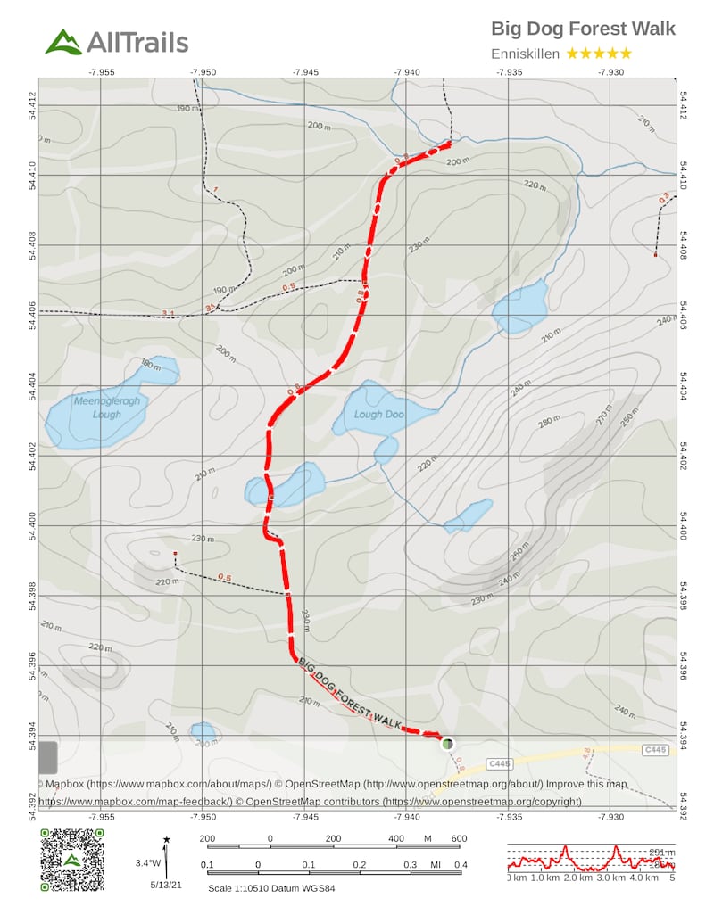
Name: Big Dog Forest – Big Dog Walk
Length: 4km
Grade: Moderate
Terrain: All types, mostly forest track, some unsurfaced path.
Route type: Linear, with circular loop.
Footwear: Road or Trail Runners
Wheelchair accessible: No
Facilities: Parking, onsite interpretation, picnic area, way marked walking route.
Background: Big Dog Forest Walk is part of the Marble Arch Caves Global Geopark. Big Dog Forest is 1,000 hectares in size and is cloaked largely with conifers. This beautiful short run allows you to explore some of Fermanagh's best upland landscapes, and the forest is inhabited by wildlife as varied as red deer, herons and dragonflies. Keep an eye out for them as you run, no doubt they'll keep an eye out for you! This is a truly special spot offering a great short run. Big Dog Forest gets its name from the larger of the two small hills that dominate the skyline, known as Big Dog and Little Dog. According to ancient folklore the hills are named after the two wolf hounds, Bran and Skeolan, who were owned by the mythical giant, Finn MacCool. Legend has it, that one day while hunting, the dogs gave chase to a witch, who cast them into stone to aid her escape. Geologists now know that the two hills are made out of a particularly resistant sandstone.
Route Information: From the car park, follow the black route as indicated by the way marked posts. The walk takes you along forest tracks, before opening out to bisect Lough Nabrickboy, providing magnificent views of this upland lake. Sunglasses will come in handy on a sunny day as light bounces off this beautiful pocket of water. Travel back towards Lough Nabrickboy before taking in Little Dog on your right. One of the highlights of this route is the short but rewarding climb to the top of Little Dog, offering great 360 degree views of the surrounding area. This will count as your hill training for the week surely? Return back towards the car park following the way marked posts.
Getting to the start: If travelling from Enniskillen, travel out along the B81 to Derrygonnelly and turn left at the end of the main street. Take the Garrison Road via Knockmore and head into the hills. Approximately 10km from Derrygonnelly, take the lane on the right signposted for Big Dog car park. From Belcoo take the Garrison Road, approximately 11km turn right at the Cashel Cross Roads; continue along the country lane, after 8km take the lane on the left signposted for Big Dog car park. (Aided by: Marble Arch Geo Park)
Galway
Name: Portumna Forest Park – Rinmaher Trail
Length: 10km
Elevation: 10m
Route type: Loop
Footwear: Road or Trail Runners.
Background: The name Portumna derives from the Irish Port Omna, meaning the landing place of the oak tree. Portumna Forest Park was acquired in 1948 and covers almost 450 hectares. It was formerly owned by the Clanrickarde family. There is an old abbey, now under the care of the Office of Public Works (OPW), within the Park which dates back to the 15th century. The castle nearby, on which considerable restoration work has been carried out by the OPW, dates back to the 17th century and was the seat of the Earl of Clanrickarde.
Scattered throughout the coniferous woodland there are occasional patches of semi-natural woodland which tend to be dominated by ash and beech with silver birch frequent along the lake shore. A notable feature of the park is the presence of occasional individuals of Yew and Juniper in open woodland along the lake shore. Perhaps the most noteworthy animal species of the park is the red squirrel, which is frequently encountered in woodland areas. There is a large population of Fallow deer in the park and other animal species include fox and badger. A recent visitor is the white-tailed sea eagle that has nested and raised chicks on an island close to the forest park.
Route Information: This loop is mainly on single track narrow trails and is perfect for those looking for a good route to do their 10km runs. It begins along a two-way section of trail and covers much of the park. There are good views along the lakeshore near Rinmaher Point south towards Terryglass and east towards Portumna Bridge. Signal signs provide information about local features of fauna and flora, including red squirrel and fallow deer. Although there are multiple trails available to each runner, I feel the Rinmaher Trail offers great bang for your buck. A lovely flat looped route that us Waymarked from start to finish with amazing forest and coastal scenes to take in along the way. (Aided by: Visit Portumna)

Kerry
Name: Glanteenassig Wood Loop to Lough Slat and Lough Caum
Length: 10.3km
Elevation gain: 252m
Route type: Loop
Footwear: Roud or Trail Runners
Background: Glanteenassig Wood Loop to Lough Slat and Lough Caum is a 10.3 kilometre moderately trafficked loop trail located near Castlegregory, County Kerry, Ireland that features a lake and is good for all skill levels. The trail offers a number of activity options.
Route Information: Starting in the Glanteenassig Wood carpark. Follow the trail head from the carpark until you meet a T junction. Tale the left hand turn which will bring you to Lough Slat. From here head towards Lough Caum. There is a magnificent wooden walkway that skirts around the lough which is one of the highlights of the trail itself. The entire area exudes a sense of wonder and natural awe, so make sure to look up and take it all in. I recommend not using headphones and enjoying the quiet bliss of this beautiful area. You will skirt around the entirety of the lough and bring you back to where you started your run around the lough. Take the left turn and in 400m the trail veers right. Follow this section of trail until the pathway again veers right and brings you back to the first junction where you will take the left hand turn to bring you back to the trailhead. Feel free to make this run into a half marathon by doing this wonderful loop twice! (Aided by: Sport Ireland and Coillte)
Kildare
Name: Donadea Forest Park – Aylmer Loop
Background: Aylmer Loop Starts from the first car park, enter the forestry at a wooden framed mapboard for a Slí na Sláinte route. Follow the arrows on the blue disc with footprints (and the Slí na Sláinte arrows) along the forestry road.
Route Information: Starting from the first car park, enter the forestry at a wooden framed mapboard for a Slí na Sláinte route. Follow the arrows on the blue disc with footprints (and the Slí na Sláinte arrows) along the forestry road for 300m to reach a T-junction where you turn right. Another 150m takes you to a three-way junction where you veer left and cross a small stream by a small concrete bridge. Continue to follow the arrows on the blue discs along the forestry road for 500m to reach a crossroads with wooden signpost. Continue straight on.
Staying on the forestry road, the loop passes a number of tracks on the left before climbing gently to reach a roadway on the left on a bend. Veer right (straight) here and past a track on your right. After 250m the loop swings right and 500m further on passes straight through a crossroads. The loop passes through a number of junctions – and at one of them merges with a Nature Trail (marked with yellow arrows and wooden Nature Point posts). Shortly afterwards the loop turns right at a four-way junction. Follow the forest road as it passes through the USA Plots area. After passing a stone memorial to the firefighters of New York killed in the 9/11 disaster, the loop turns right and emerges into a popular recreation area that contains a lake, cafe, and the ruins of Donadea Castle. The car park from which you started is only 200m from the castle.
The name Donadea derives from the Irish word “Domnach”, which signifies a church and also Sunday. It is believed that all churches bearing this name were founded by St Patrick, and the foundations were marked out on a Sunday. One of the earliest references of the manor of Donadea was in connection with an inquisition taken in Cloncurry in 1312 – and in 1621, King James I created Gerald the first Baronet of Donadea.
By the mid-1800s the Donadea estates were one of the largest in Co Kildare, amounting to almost 16,000 acres. It was around this time that extensive development occurred in the grounds surrounding the castle. The works included the construction of a stone wall surrounding almost 600 acres, the development of an artificial lake, a massive programme of tree planting within the demesne and the realignment of existing roads. In 1936 the Irish land commission acquired the lands of Donadea from the Aylmer estate. In 1981 Donadea Demesne was opened to the public and the estate is at present under the care and maintenance of Coillte (the Irish Forestry Board). This loop is one of a network of forestry trails created by Coillte as part of its Coillte Outdoors Programme. It meanders along forest roads and paths incorporating Lime Tree Avenue, and the 9/11 Memorial. (Aided by: Discover Ireland and Coillte)

Kilkenny
Name: Brandon Hill Loop – Trailhead Graiguenamanagh
Distance: 19km
Elevation: 520m/600m
Difficulty: Moderate to hard
Terrain: Minor roadways, forestry tracks and hillside paths
Footwear: Road or Trail Runners
Directions to Trailhead: Brandon Hill loop starts in the town of Graiguenamanagh. The trailhead is at the Barrow Valley Activities Hub located on the River Barrow. Turn right immediately before the bridge.
Route Information: Starting from the trailhead, follow the purple arrows turning left at the bridge and immediately left again. You are also following the yellow arrows of the South Leinster Way. Turn left again, run 500m to a cul-de-sac at the side of the town bypass. Cross the road to join a minor road. Follow this road for 200m to reach a junction with another minor road on your left. Turn left here. Follow this road for almost 2km where it merges into a forestry roadway – still following the purple and yellow arrows. After 200m the forestry track turns a right bend and passes through a barrier into Gorlough Wood. 300m later you reach a three-way junction where the South Leinster Way continues straight, but you turn left.
Continue to follow purple arrows along a forestry track for 3km to reach another three-way junction where the loop veers right. Ascend along the forestry track as it zig-zags and then skirts around Ballinvarry Hill. After nearly 2km, you reach a crossroads of tracks where the loop turns sharp right onto a “green” roadway and starts the ascent toward Brandon Hill. After 500m of a climb, you reach a concrete stile and join a track where you turn right along the top of forestry and open hillside on your left. Pay close attention now because less than 200m later you will turn left again and join a path on the hillside which will take you to the top of Brandon Hill.
From the top, look for a waymarker which points you onto a stony path which marks the start of your inward journey. The path zig-zags and descends downhill to reach the edge of forestry where you veer right on to a forestry road. After nearly 1km you reach a Y-junction where the loop rejoins the South Leinster Way. Veer right and start to descend again into Gorlough Wood – following the purple and yellow arrows. Pass by the site of Reneys Well to rejoin the three-way junction where you started the loop. This time, proceed straight and follow the purple (and yellow) arrows back to the town of Graiguenamanagh. (Aided by: Coillte)
Laois
Name: Leafy Loop Walk Durrow
Length: 21.4 km
Elevation gain: 530m
Route type: Loop
Footwear: Road or Trail Runners
Route Information: The Leafy Loop around Durrow climbs to The Ballagh. It's a glorious run through forests, by rivers, up hills to oversee the valley, and down into the charming village of Durrow itself. The Leafy Loop is a longer version of the Dunmore Loop, which follows the same route until a divergence just before Clonageera House on the other side of the village. If you feel like a shorter run the day, take the Dunmore Loop which is 14.5km in length. You get to see many of the fine sights along the way then climb to see the magnificent valley. It's more than 4 miles (6.4km), but if you're fit, it is well worth it.
This walk is well signposted with a variety of posts along the way. Purple arrows indicate the signs for the Leafy Loop and have been placed with thought and care by people who are keen to keep you on the right path at all times. The trail immediately lived up to its "Leafy Loop" moniker and continued to do so. Durrow means "Plain of the Oak" and this area was reputed to have woods so dense in the 18th century that the outlaw Jeremiah Grant and his gang of ne'er do wells were able to hide out with ease. It wasn't until the early post-independence days that mass felling took place making the current tree cover a precious thing. (Aided by: Laois Tourism)
Leitrim
Name: Drumleague Lock Loop
Grade: Easy
Length: 5km
Terrain: Canal Path
Footwear: Road or Trail Runners
Waymarking: Yes
Dogs allowed: Yes – on a lead.
Facilities nearby: Leitrim Village 1km – cafes, shops, pubs, restaurants and accommodation
Start Point: Battlebridge Lock near Leitrim Village
Getting to the start: In Leitrim Village take the left turn for Keadue (R284). In 1 km watch for a stone bridge which crosses the canal. Turn left just before and travel 100m to reach Battlebridge Lock. The trailhead is located at the mapboard.
Route Information: The 5km the Drumleague Lock Loop walk starts at Battlebridge Lock and takes you alongside the canal to Drumleague Lock. After crossing the canal at the Lock, follow the trail back to Battlebridge Lock. Start from the mapboard at Battlebridge Lock and follow the red and purple arrows for 100m to reach the tarred road. Continue straight here following the roadway along the right bank of the canal. Continue to follow the red and purple arrows along this minor road for approximately 2.5km to reach Drumleague Lock and Bridge.
The Drumhauver Bridge Loop continues straight here but you turn left, cross the bridge and turn left again to join the other side of the canal. Now follow the red and purple arrows as the loop takes you along this grassy canal bank for 2.5km to reach the tarred road again at Battlebridge. Exit with care, turn left, cross the bridge and turn right towards Battlebridge Lock and the trailhead. You can choose to extend the run further by continuing on the Drumhauver Bridge Loop and the Acres Lake Boardwalk. (Aided by: Leitrim Tourism)
Limerick
Name: Ballinaboola Loop
Grade: Moderate
Length: 10km
Time: 2 hours 30 minutes
Format: Loop
Ascent: 200m
Waymarking: Purple arrow
Start/finish Point: Ballinaboola Woods Car Park, Ardpatrick
Route information: This loop takes you on forestry roads and tracks as it ascends the shoulder of Knockduv Mountain before descending and running below the Knockduv ridge and Knocknatallig, giving views over the surrounding countryside of the Golden Vale. It is crossed in places by cycle tracks. (Aided by: Coillte)

Longford
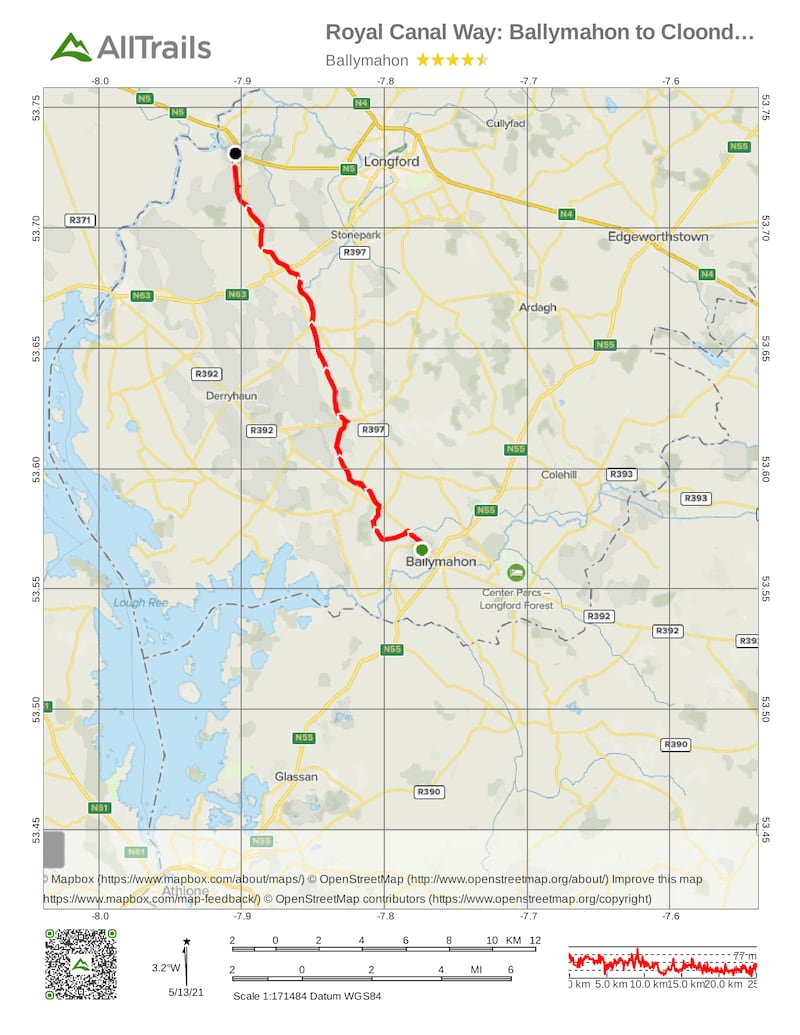
Name: Royal Canal Way: Ballymahon to Cloondara
Length: 25.3km
Elevation gain: 415m
Route type: Point to point
Route Information: One of the biggest towns along the Royal Canal Greenway, Longford is full of great accommodation options and places to eat and drink after a busy day walking or cycling along the Greenway. Located 122km from Dublin and 91km from Sligo, Longford lies on the Dublin to Sligo line of the Irish railway network so is easily accessed by train or by car. Alternatively begin your journey from the tranquil harbour village of Cloondara. This picturesque village is home to plenty of barge boats and the final lock of the canal. From this location you can also explore the Shannon Blueway.
Follow the Greenway South from Longford Town: From Longford Town access the Greenway from Canal Walk and follow the 8km Longford Branch line of the Royal Canal. This completely flat route provides an excellent way to enjoy some of Longford's unspoilt landscape. As you reach the Royal Canal Greenway, the choice is yours whether to journey north along the canal towards Cloondara.
Follow the Greenway North to Cloondara: Once you reach the Royal Canal, follow it north for a further 8km to Cloondara village. This section provides a tranquil and safe environment along the quiet banks of the Royal Canal.
Follow the Greenway South from Cloondara: From Cloondara follow the greenway South along quiet off-road trails past a series of lock gates towards Keenagh and Ballymahon. A great place to stop along this section of trail is the Corlea Trackway Visitor Centre located close to the Greenway at Keenagh. (Aided by: Longford.ie)
Louth
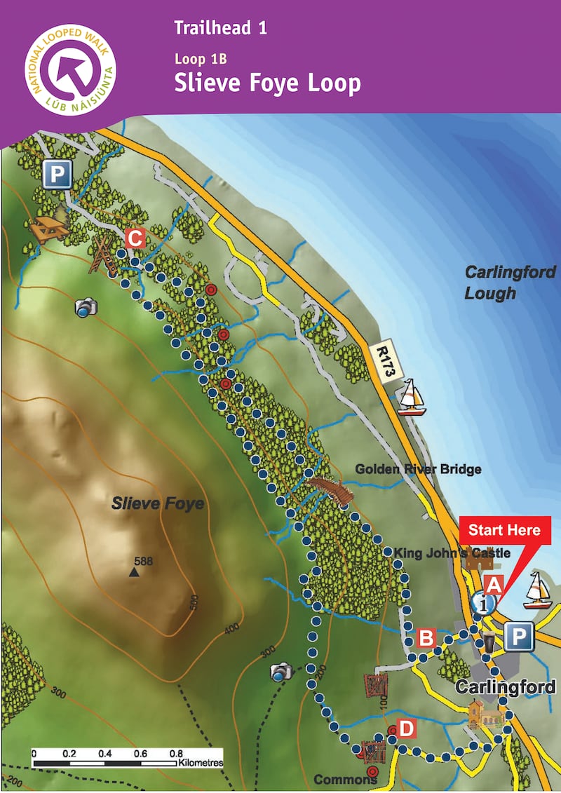
Name: Slieve Foye Loop
Length: 9km
Waymarkers: Blue arrows
Route type: Loop
Elevation: 270m
Footwear: Road or Trail Runners
Dog Policy: Dogs are not permitted on farmland.
Route Information: This National loop walk brings you up to the mountains slopes above Carlingford. The walk is mostly on good paths marked with blue arrows. From the car park turn left and follow the blue (and green and red) arrows along the road to a T-junction where you turn left. The green arrows are for the shorter Commons Loop, the red for the longer Barnavave Loop. Entering the village "square" turn right and ascend to the main junction where you proceed straight on to the right of Savages Victuallers. Continue to follow the green, blue and red arrows (and the yellow arrows which are for the long-distance Táin Way) as the loop takes you to the top of River Road. The green loop goes straight ahead here – but you turn right onto a sandy roadway.
Follow the blue, red and yellow arrows along the roadway past gates and into forestry. The loop travels through the forestry for more than 1km before reaching a forestry track (on the left) where the two loops turn left and leave the Táin Way. Now you ascend gently to reach the edge of forestry and a 20m climb takes you to a stile over a wire fence. Cross the stile, turn left, and follow the wire fence for 1km to reach the end of the forestry. Veer right here. Continue to follow the blue and red arrows for 300m to reach a bend in a grassy roadway where you rejoin the Táin Way. The red loop turns right here – but you veer left and downhill. Follow the grassy roadway for 500m to reach a wooden gate – pass through it and follow the arrows to the left. The loop now sweeps downhill and right and, after 500m, joins a surfaced roadway. Here you rejoin the Barnavave Loop and turn left and downhill. The loop takes you down to the parish church on the outskirts of the village and then turns left and back to the village square. It's only 100m from there to the trailhead. (Aided by: Visit Louth & Sport Ireland)
Mayo
Name: The Great Western Greenway
The Great Western Greenway has transformed the 43.5km long old rail route between Westport and Achill. Ireland's longest greenway is a chance for cyclists and walkers of all abilities to get off the beaten track and soak up the stunning views and exceptional scenery that the west of Ireland is famous for. It's the perfect activity to plan a short getaway to Mayo around.
One of the biggest advantages of the route is that it allows you to get out into the countryside without having to tackle dirt tracks or negotiate uneven country lanes. So you can enjoy the peace and tranquillity of Mayo without the noise and traffic of a main road. The smooth, level track is ideal for cycling and it’s easy to rent a bike for the day at Westport Bike Hire or Clew Bay Bike Hire. You can also take advantage of drop off points and a free shuttle service at different locations along the greenway so you don’t have to commit to doing the whole trip in one go. Take in beautiful views along the Great Western Greenway in Co Mayo
Westport to Newport (12.5km)
This section of the route starts off in the charming town of Westport, which has no shortage of boutique shops, great eateries and excellent pubs. This portion of the greenway route takes in some stunning Atlantic seascapes and you can look out over Clew Bay, which is dotted with small islands. Finish up in the lively heritage town of Newport on the shores of Clew Bay, which is a renowned fishing spot.
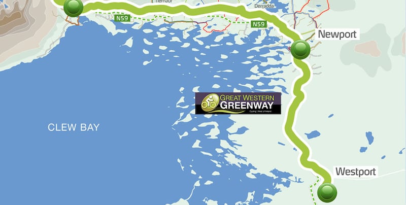
Newport to Mulranny (18km)
The next section takes you on to Mulranny and you'll get to see impressive views of Clew Bay, Clare Island and the rugged Nephin Beg mountain range. One unique feature on this section is the eye-catching Mulranny causeway, a narrow bridge that crosses Trawoughter Bay and links the village to Mulranny's blue flag beach. This serene beach is a great spot for a dip on a good day. Be sure to keep your eyes peeled for the town's famous old Irish goats. If you're lucky, you'll catch a glimpse of these rare, big-horned locals as you pass through these parts.
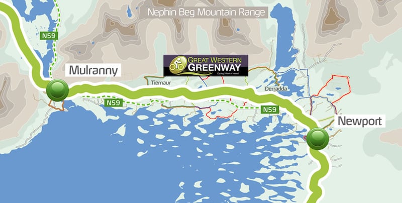
Mulranny to Achill Sound (13km)
This section will take you from Mulranny to Achill Sound, the first village you encounter when you cross on to the beautiful Achill Island from the mainland. Prepare to enjoy some spectacular island sights and some of the country's most dramatic coastal scenery when you get there. Make sure your phone is charged as you'll definitely want to grab some photos along the way. Soaring sea cliffs, breathtaking views and a friendly island welcome await you when you complete your trip. Celebrate with a pint or a coffee or just relax and soak up some of the island's natural charms. This is a chance to get away from it all and explore the old railway route under your own steam and at your own pace. (Aided by: Mayo Walks and Greenway.ie)

Meath
Name: Kells Girley Bog Eco Walk
Ascent: 20m
Distance: 6km
Grade: Moderate
Footwear: Road or Trail Runners
Services: Kells (7.5km)
Terrain: Bog roads, forestry tracks and woodland
Theme: Nature
Trailhead: Drewstown Woods, near Kells, Co Meath
Route information: Girley Bog is a site of considerable conservation significance as it comprises raised bog, a rare habitat in Europe and one that is becoming increasingly scarce and under threat in Ireland. Leaving the trailhead, the trail follows a forestry track for 600 metres to a crossroads from where the loop proper begins. Turn right here. The loop travels another 1km to reach the end of an old bog road. Here it turns left onto a woodland trail. Now the loop passes through deciduous woodland and coniferous forestry to exit onto a forestry roadway. Turn left here.
Follow the forestry roadway for 1km before turning left and joining an access road to bogland. Climb a stile at a gateway and follow a grassy track for 300 metres before turning left, and crossing a short section of bog before joining a bog roadway where you turn right at an interpretive panel. After a short distance the loop turns sharp right and follows a track through a line of trees. Exiting the trees, the loop turns left onto an old bog road again and for the next 2km circles a raised bog area. The loop rejoins the outward section at the crossroads mentioned at B above, where it goes straight and covers the final 600 metres to the trailhead.
Throughout most of history Irish bogs were impassable. To cross the wet, boggy terrain people built bog roads or “toghers”. In the 20th century, as the bogs were exploited for fuel, thousands of important archaeological finds were made, including swords, jewellery, trumpets and human bodies (preserved by the acid nature of the bog). Another interesting use of the bog was to keep butter cool during summer and there have been many finds of butter kept in wooden container called “methers”.
Girley Bog is a site of considerable conservation significance as it comprises raised bog, a rare habitat in Europe and one that is becoming increasingly scarce and under threat in Ireland. The loop covers a variety of landscape of forest and bogland and has been developed as an eco-walk with interpretive panels throughout. The early section traverses coniferous forestry planted on high bog, the trees are fast growing species (sitka spruce and lodgepole pine) that originate in North America. The main element of the loop is within the bogland where there is a wonderful variety of birdlife, plants and animals. (Aided by: Meath.ie)
Monaghan
Name: Rossmore Park
Length: 8km
Route type: Loop
Footwear: Road or Trail Runners
Route Information: There are six looped walking trails in the forest park which cater for all abilities and they are colour coded for ease of use. The trails include the following:
The "Access for all Trail" (0.8 km, 30 mins, red markers)
The "Barn Hill Lake Loop" (1.7 km, 45 mins, orange markers)
The "Twin Lakes Loop" (2.6 km, 1 hour, white markers)
The "Priestfield Lake Loop" (2.9 km, 1 hour, green markers)
The "Castle Trail" (3.0 km, 1 hour, brown markers)
The "Rossmore Loop" (8.0 km, 2.5 hours, blue markers)
Picnic areas, car park facilities and a newly developed children's playpark are all available within the park. Admission is free and opening times are daylight hours. Rossmore Forest Park is part of an estate of land that was granted to the Blayney family as part of the Plantation of Ulster in the early 1600s. It passed to the Westenra family in the early 1800s and it was Warner Westenra, the 3rd Lord Rossmore who commenced the building in 1827 of Rossmore Castle in Tudor Gothic style, to the designs of William Vitruvius Morrison.
A main feature of the original building was a large square tower and turret with crow step battlements. An extension added in 1858 featured two towers, one with a polygonal turret and cupola. A competition developed over the years between Lord Rossmore and Mr Shirley of Lough Fea, as to which of them could claim to have the largest room in County Monaghan.
As a result the drawing room in Rossmore Castle was enlarged five times. Eventually the combined changes and additions resulted in a building with three towers and more than 117 windows in 53 different shapes and sizes. After the second World War the house developed a severe case of dry rot and the family were forced to leave. The castle was eventually demolished in 1974 for safety reasons. The estate was acquired by the State in the 1950s and replanted with a mixture of conifer and broadleaf trees. Conifer species include Sitka Spruce, Douglas Fir and Noway Spruce. Broadleaf trees include beech, oak and poplar. There are many self-seeding "scrub" trees such as birch and alder.
Notable in the park are some of the original estate trees including giant redwoods, yew, scots pine, cedars and monkey puzzle. Many sites associated with the house can be seen around the forest park: the entrance gates and gate lodges, old walled gardens, pet cemetery, hydraulic ram, fish hatchery, man made lakes, wells and the mausoleum for family burials (private) located peacefully beside a waterfall.
The hydraulic ram which is located beside the river was used to raise water uphill to the house. The device invented in 1772 has only two moving parts, a spring or weight loaded waste valve sometimes known as the "clack" valve and a delivery valve. Water flows into the structure, pushes the weight or "ram" upwards. The waste valve closes and the ram now drives the water uphill as it falls. (Aided by: Monaghan Tourism)
Offaly
Name: Kinnitty Castle Loop
Length: 4km
Markers: Green
Services: Kinnitty Village (3km)
Terrain: Easy Forestry Tracks
Footwear: Road or Trail Runners
Route Information: Start from the trailhead at the forestry entrance. After 30m keep left at the Y-junction of forestry roads following the green arrow. You are also following the blue arrows of the Glinsk Castle loop, and the yellow arrows for the long-distance Slieve Bloom Way. After a little more than 1km you reach a three-way junction with a wooden gate on your left. [Going through the wooden gate will take you into the grounds of Kinnitty Castle – well worth a visit.]
Your loop turns right (uphill) here, and continues to ascend along a forest track for almost 1km before rounding a right bend and reaching a Y-junction. Veer to the right here – still following the Slieve Bloom Way and the red and green loops. After 500m the blue loop and Slieve Bloom Way turn left onto an uphill woodland trail – but you continue straight on here. Continue to follow the forest track downhill to reach a three-way junction – veer right here. It is only 300m back to the trailhead. (Aided by: Slievebloom.ie)
Roscommon
Name: Lough Key Forest Park Slí
Length: 3km-4km
Dogs Allowed: Yes – On lead
Buggy Accessible: Yes
Trail description: Have a run through Lough Key Forest Park. This 350 hectare park of amazing natural beauty, combines woodland and water with a wealth of points of interest including – Bog Garden, Fairy Bridge, Ice House and a Wishing Chair together with a variety of on-site and local facilities and attractions. There is so much to see and do for all ages in Lough Key.
Route Information: Lough Key offers a range of trails for runners, all trailheads starting from the car park. The Drumman's Island Trail (Green Trail) is 3.5km in length and skirts around the lough and takes you on a short loop around Drumman's Island. The Miners Way Historical Trail (Purple Trail) is the longest of the routes at 4.2km in length. It runs through Irish woodland and takes you along the eastern side of Erris Bay. The Bog Garden Trail (Red Trail) is for those who prefer a shaded forest to a breezy lough shoreline and is 4km in length. The short of the available routes is Slí na Sláinte at 3km in length. It is also the only non-circular route and is an Out and Back route. Whatever type of run takes your fancy you will find it on Lough Key's trails. (Aided by: Visit Roscommon)
Sligo
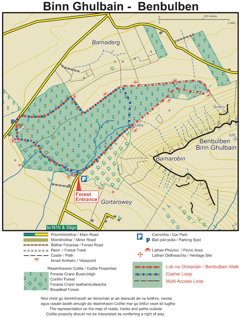
Name: Benbulben Forest Loop
Difficulty level: As this Benbulben run doesn't actually involve climbing the mountain, the trail is quite flat which makes it a great place for faster training runs.
Parking: The car park for the Benbulben loop is located just off the N15, 8km north of Sligo. Throw "Gortarowey Forest Recreation Area" into Google Maps and it'll take you to the car park. The turnoff is signposted and it's a simple walk from there once you're parked up.
What to bring with you: While not the most the challenging walk, it's still important to be comfortable on the Benbulben forest loop. Take some sturdy walking boots and weather appropriate coats or jackets depending on what the weather is set to be like. Check your weather app in the morning and pack appropriately. A bottle of water and a few snacks never go amiss either.
Route information: The Benbulben forest loop is a great run for anyone looking to get out of the city and into the trails under the watchful eye of the Benbulben mountainside. Also known as the Gortarowey loop, this Benbulben loop is a looped route that starts in a sheltered forest before emerging alongside the grandeur of Benbulben, the most unique of the many mountains in Sligo. After a jaunt in the shadow of the ancient mountain, you'll then loop back to encounter some stunning panoramic bay views before then turning for home. The Benbulben loop is perfect for those looking to change scenery for their 5km run or if you desire a peaceful place to run multiple loops for your weekly 10km run.
The trail is quite flat and will give you an opportunity to take in the natural surroundings should you wish to. Or feel free to let loose and gun it around the loop for your new 5 or 10km personal best. You’ll start this run off from the car park at Gortarowey Forest Recreation Area. From the car park, the initial stretch is a short run through pretty shaded woodland that conceals the natural splendour of what lies ahead. Once you’re through the preliminary section of forest, you’ll emerge into an opening where the vast form of Benbulben head rises up on your right-hand side. Follow this gravel path and appreciate the striking close-up views of Benbulben mountain that this path affords you. If you’re here on a sunny day when the light glints off the side of the mountain, even better! Once you’re parallel with the mountain summit, thick forest on the left-hand side starts to form and will stay alongside the path for the majority of the trail.
On this Benbulben Loop, you'll come across an array of colourful flora, as well as foxes and wild hares. The Sligo countryside also contains many varieties of tree to look out for on the way. The path then turns right, providing the best chance of getting up close and personal with the mountain. Once you've got your close-up photo of Benbulben for Strava, the path then loops left and the landscape totally changes, presenting gorgeous sloping views beyond fields, forest and roads towards Donegal Bay. On a clear day, the jagged peaks of Slieve League should be visible across Donegal Bay, as should the stately spires of Classiebawn Castle and the rest of Mullaghmore head. Speaking of stunning views, if you take on a Benbulben hike and the weather is playing ball (never a guarantee), you should even be able to get a glimpse of Croagh Patrick from the summit.
Continuing the path along the forest and with Benbulben to your left, you’ll eventually be treated some more spectacular vistas, except this time it’ll be Sligo Bay that you’re looking towards. Beyond the slanting countryside, farmland and shimmering water, the grand outlines of the Ox Mountains will be visible in the distance. The unusual but no less magnificent outline of the 1000ft-high Knocknarea should also be clear.
Making your way back to the car park: The path will eventually turn left, and you'll head back through a forest trail and towards the car park where the loop comes to an end. Timing is never easy but for the most epic experience of the Benbulben run, try to head out on a clear day at late afternoon or early evening (depending on the time of year) so you can catch the golden light of the low sun on the steepest sides of the mountain. You'll also be able to catch a gorgeous orange sunset as it goes down beneath Sligo Bay. Other great spots to visit in the area, if you have the time, include Strandhill, Mullaghmore and Glencar Waterfall. (Aided by: activeme.ie and Sligo Walks)
Tipperary
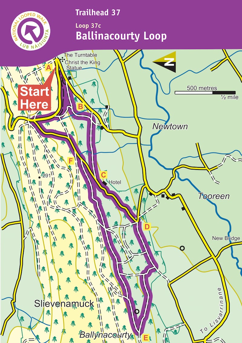
Name: Glen of Aherlow – Ballinacourty loop
Grade: Moderate
Length: 6km
Format: Loop
Ascent: 240m
Dogs Allowed: Yes
Footwear: Road or Trail Runners
Waymarking: Purple arrow on yellow background
Start/Finish Point: Christ the King statue, Glen of Aherlow
Nearest Town to Start: Lisvarrinane
Route information: From the mapboard in the green area at Christ the King statue follow downhill to enter the Nature Park. This loop is marked with purple arrows – but overlaps with two other loops (green and light blue arrows) and the long-distance Ballyhoura Way which is marked with the familiar yellow walking man and arrows. Descend wooden steps and over a footbridge and shortly afterwards you reach a Y-junction. Veer left here and follow the woodland trail for approximately 1km to reach a wooden stile. Exiting the stile the green loop turns right – you turn left.
You are now on a more substantial forestry track. Descend for 300m to reach a four-track junction where you turn right and follow a forestry track for 800m to exit at a surfaced road just uphill from the Aherlow House Hotel. Here you leave the light blue loop and turn downhill following the yellow Ballyhoura Way. Pass the hotel and follow the tarred surface downhill to reach a sharp left bend where you turn right and enter forestry again. Continue to follow the Ballyhoura Way along forestry tracks for a flat section before turning right and ascending through Ballynacourty Woods. After 1.5km you reach a T-junction where the Ballyhoura Way turns left and you overlap with other loops that start and finish in the village of Lisvarrinane. You turn right here to begin the homeward journey.
For more than 2km the loop traverses the southern shoulder of Slievenamuck Mountain and rejoins the light blue loop above the Aherlow House Hotel before joining a tarred roadway. Here you veer left. Follow the tarred roadway for a short distance before turning right into forestry again. Following woodland trails, you pick up the green loop at a small stile, and after 1km reach a three-way junction where you rejoin the outward route. Veer left and retrace your steps for 300m to regain the trailhead. (Aided by: Coillte)
Tyrone
Name: Coalisland Canal Walk
Length: 16km (Return)
Terrain: Part Tarmac/ Part Unsurfaced
Route type: Linear (Out and Back)
Background: This is a walk along the towpath of the Coalisland Canal. The canal was opened in 1789 to bring coal from Coalisland to Dublin via the River Blackwater, Lough Neagh and Newry Canal. Coalisland acted as an inland port with lighters carrying grain for the mills and provisions for the surrounding towns. Between Macks Bridge and Moor Bridge the River Torrent is one side of the Towptath and the canal is on the other.
Route Information: The walk begins at the Cornmill in Coalisland town centre. The towpath is a straight walk along the 4.5 mile stretch. However, it has three sections after about 1600m runners will have to cross the Gortgonis Road at Macks bridge to access the second section of the run. A further 800m along this pathway will lead to the busy Moor road at McAliskeys lock, once again you must cross this road to connect to the last part of the run, the final 5km will lead to the Reenaderry Road where the canal path ends, this is known as The Point where the canal meets the Blackwater river.
Take turn off for junction 14 on the M1 motorway and follow the A45 to Coalisland. Park at Cornmill carpark in the centre of Coalisland. Exit the carpark opposite Dorman's chemist, turn left and run 50m until you come to the dam lock. Whether you get a thin fog rolling atop the canal in the early morning or you have rays of sunshine hitting the canal waters you're sure to enjoy your run in the wonderful gem in Tyrone. (Aided by: Trek NI)
Waterford
Name: Anne Valley Route, Dunhill
Length: 9.6km (return)
Route type: Linear (Out and Back)
Terrain: Gravel pathway
Footwear: Road or Trail Runners
Background: The Anne Valley walk was developed by local landowners and the community. The almost 5 km the run winds through a protected wildlife area of forest and marshland next to the river Anne. If you are lucky you may see some of the many protected wildlife species such as the heron, kingfisher or otter and an amazing range of other fauna and flora. A most awe inspiring sight along the walk is the view of Dunhill Castle.
Location of Trailhead: Ample car parking is afforded at the start of this wonderful trail in the village of Dunhill which is central to many other towns and villages in Waterford including Tramore 12km, Dungarvan 32km and Waterford 17km.
Make sure that you give yourself enough time to check out the amazing flora and fauna that make their home along the Anne Valley Walk. The birdsong and insects busying themselves among the flowers brings a certain serenity to the route. So if you're trying to do a 5km or 10km time trial along this route make sure you take your recovery walking along the route to take in nature at its finest. (Aided by: Coillte)

Westmeath
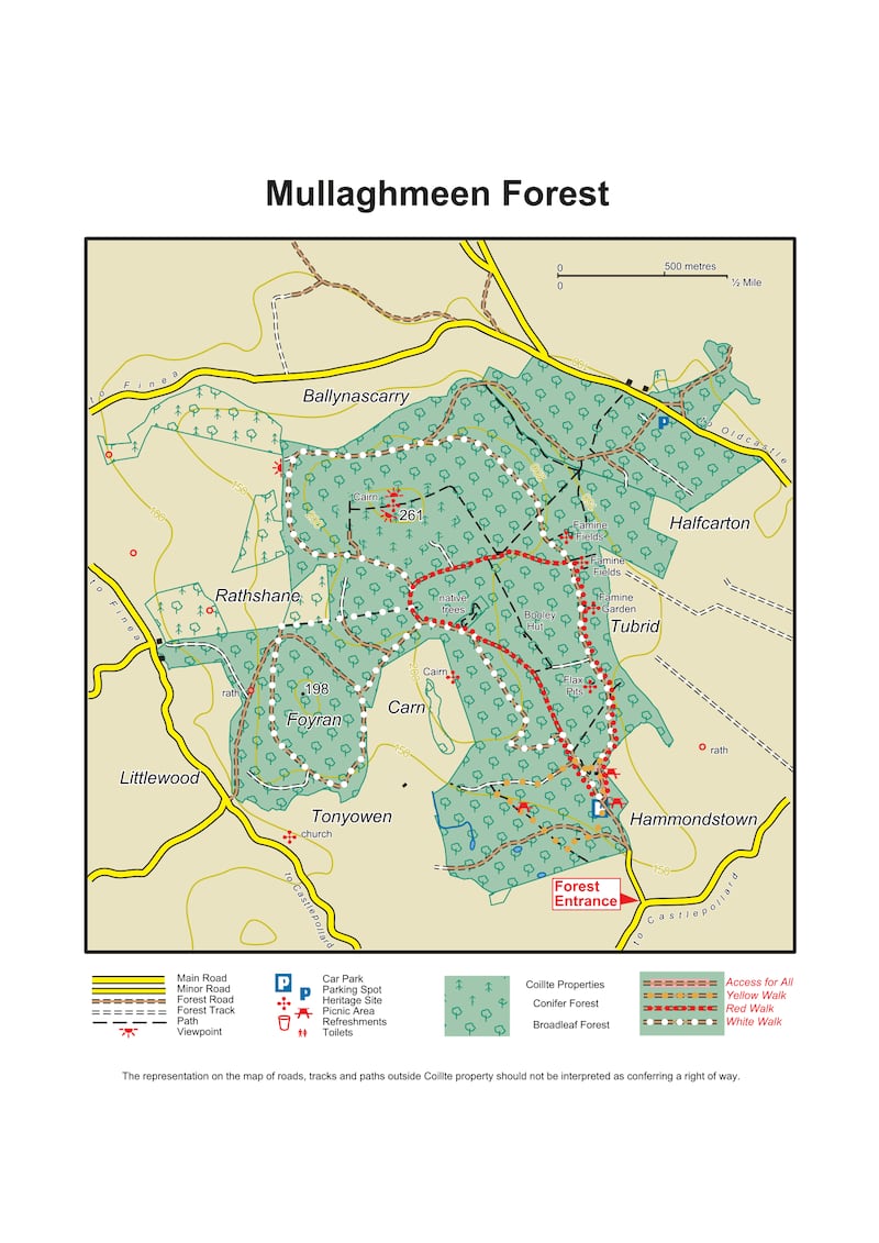
Name: Mullaghmeen Forest (White Loop)
Difficulty: Moderate
Length: 8km
Format: Loop
Dogs: Allowed under effective control
Footwear: Road or Trail Runners
Background: Mullaghmeen in north Westmeath is the largest planted beech forest in Ireland. This 1,000 acre forest has an extensive network of way marked trails for varying levels of fitness.
Mullaghmeen is located approximately 8km west of Oldcastle, Co Meath and is an isolated area of forest rising above the farm land of north Westmeath. Mullaghmeen Forest is the largest planted beech forest in Ireland. Along with beech, Mullaghmeen also has Sitka spruce, Scots pine and noble fir and a very interesting native tree collection. This 1,000 acre forest offers picnickers a shady haven in which to feast and provides the more energetic with scenic walks of varying length. The Red Trail takes you to the summit of Mullaghmeen and provides magnificent views north across Lough Sheelin and into the neighbouring county of Cavan.
The forest, once an out farm belonging to a Lord Gradwell, has many examples of man's former impacts on the landscape. Following the White Trail (one of the walking trails) one passes sad reminders of famine times with relic walls of famine fields. A Booley Hut, a summer grazing shelter, is just off the Red Trail, while the Flax Pits show that this important crop for the linen industry was once harvested and cured in this area. The underlying geology is limestone rock and in the south-eastern corner more of its geology is revealed where one can see turloughs: disappearing lakes that fill and empty with no apparent in or outflow. Come in spring for the best displays of woodland flowers notably bluebells. The area is populated with grey squirrels, jays, badgers, foxes, pheasant, rabbit and hares, as well as a large selection of song birds. (Aided by: Sport Ireland and Coillte)
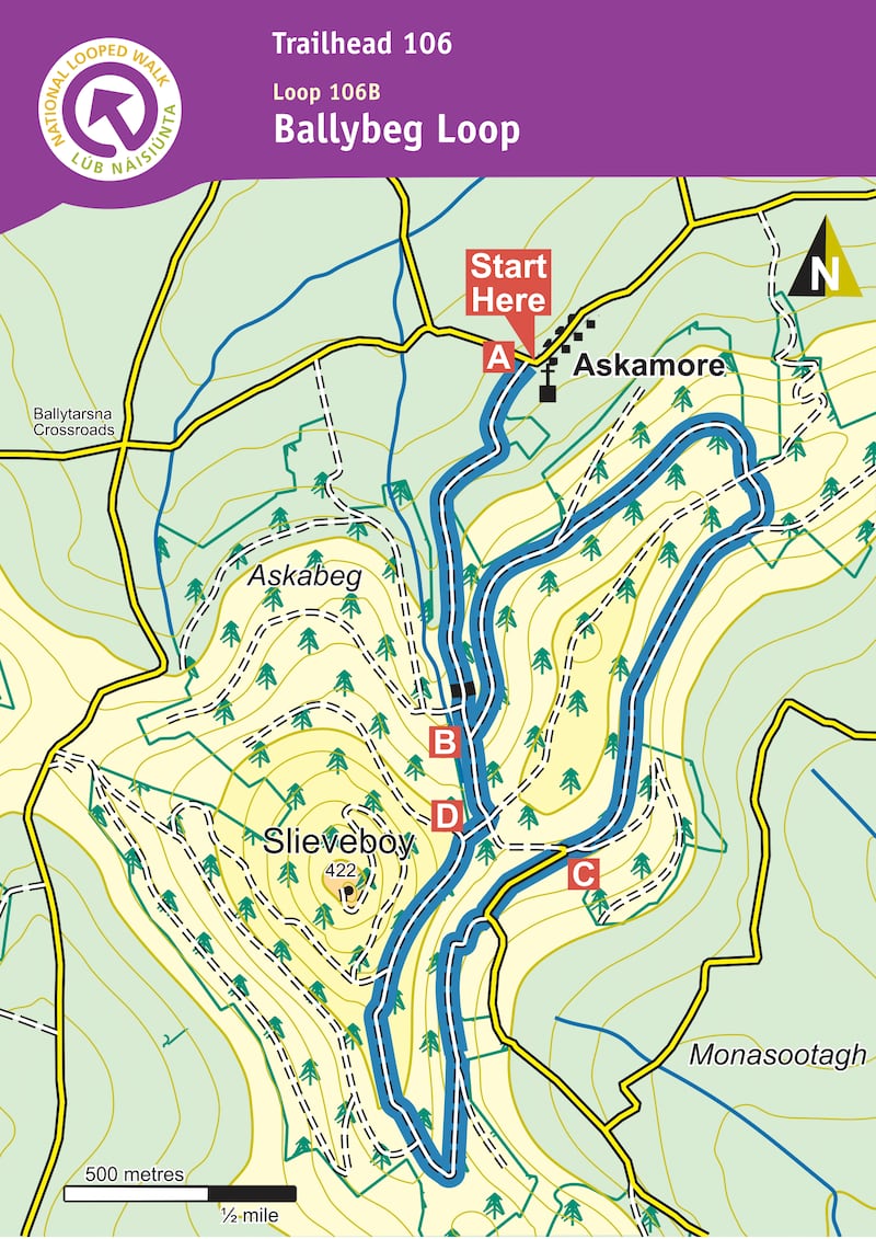
Wexford
Name: Ballybeg Loop
Background: This loop follows blue arrows in a clockwise loop through Askamore Forest, on sandy lane, forest road, forest track and tarred road. It climbs and descends steadily on the access lane to the loop while the loop itself is more-or-less level, apart from a gradual ascent towards the southern end and an ascent and descent along the slopes of Slieveboy. There are some fine views of the surrounding countryside.
Route information: From the trailhead cross the road and follow the blue (and green and purple) arrows onto the sandy lane between the church and Doran's pub. The green arrows are for the shorter Askamore Loop, the purple arrows are for the longer Slieveboy Loop. Continue along the sandy lane for more than 1km to a junction with a forestry road on your left. The loop proper begins here – you will return to this point from the opposite direction later – for now, turn left. Continue to follow the blue (and green and purple) arrows along the forestry road for 3km – enjoying some fine views of the surrounding countryside as you go – before rejoining the sandy lane at what is known locally as the "hairpin". The green loop veers right here – you veer left following the blue (and purple) arrows.
Follow the surfaced roadway downhill for 200m to a sharp left bend – and veer right onto a narrow forestry track. Continue to follow this track as it ascends over the next 500m to reach a 3-way junction where the purple loop turns left – but you continue straight ahead. After 300m you pass a junction where the purple loop rejoins from your left – continue straight and after 300m you exit forestry and rejoin the sandy lane you started out on. Turn left and downhill. After only 200m you reach the junction at B above from where you began the loop. This time proceed straight ahead and enjoy the 1km back to the trailhead. (Aided by: Sport Ireland and Coillte)
Wicklow
Name: The Devil's Glen
Car Park: Opens at 8am, closes at 5pm
Background: The Devil's Glen boasts a dramatic landscape that was fashioned at the end of the Ice Age when the melt waters of the ice sheet created the valley. The resultant gorge affords a swift decent for the Vartry River as it makes its way from the Vartry Reservoir to nearby Ashford village. The site hosts a mixture of broad leaf and conifer forest with fine stands of beech, Spanish chestnut and ash. The steep rock face of the gorge has been colonised by various species of plant life: lichens, mosses and the polypody fern. The site was once part of the Glanmore estate, former ancestral home of John Millington Synge. On the northern bank of the river you can see the privately owned Tottenham Estate.
Two car-parks service the Devils Glen. One of these car parks is located at the County road close to the start of the Seamus Heaney way this car park has a capacity of five cars and is always accessible. A second car park with a capacity of 25 cars and a coach park are located at the start of the Waterfall Walk, access to these parking areas is limited to 9am to 5pm daily the opening hours of the barrier to the Devils Glen.
Route information: The wood has two looped walks these trails are waymarked. The Seamus Heaney Walk (4km, 2hrs, moderate), named in honour of the poet and Nobel Prize winner, is a lovely run through the high forest. On the Waterfall Walk (5km, 2hrs, moderate) the waterfall marks the spot where the Vartry enters the Devil's Glen en route to the sea. Prior to the construction of the Vartry Reservoir (1860s) the roar from the waterfall was much greater than it is today. Its echo through the gorge sounded as a "Satanic power announcing some great doom" and gave the glen its popular name. The Seamus Heaney Walk Starts at the lower car park and joins the waterfall loop. You can make the 4km Heaney loop into a 9km loop taking in the wonderful waterfall on the waterfall loop. It may slow you down but it is definitely worth heading up to the viewing point of the waterfall itself to hear its thunderous roar. (Aided by: Sport Ireland and Coillte)