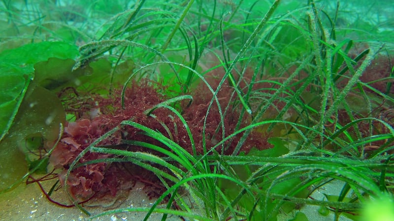
The presence or absence of sub-tidal or inter-tidal seagrass beds on sandy stretches of the Irish coastline has become a hot topic.
The value of seagrass beds as a habitat for marine creatures (including as nurseries for commercial fish) and bird species, such as migratory Brent Geese, is well known, but their value for carbon storage has gained much more attention recently.
Researchers estimate that while seagrass only covers about 0.1 per cent of the ocean floor, it is responsible for 13 per cent of the carbon stored in the ocean – referred to as “blue carbon”.
And some experts suggest that fully functioning seagrass beds can sequester twice the carbon as land-based trees. As sea waters rise, these seagrasses – with their root system on the seabed – can also help prevent erosion and reduce storm surges through the build up of sediment.
Dave Wall, citizen science officer at the National Biological Data Centre (NBDC), says the growing fascination with seagrass is also because people think it's exotic.
“They expect to see it in warmer climates rather than a bay in Kerry. People are likely to encounter it in the inter-tidal areas or when snorkelling or swimming in sheltered sandy bays.”
He says while seagrass is mostly found on the west coast, there are some seagrass beds on the east coast near Bull Island, around Lambay Island, on the Wexford coast and the north coast of Strangford Lough.
The problem is that one-third of these so-called blue carbon sinks (which also include salt marshes and mangrove forests) have been lost in recent decades. And in Europe two per cent of blue carbon ecosystems are degraded every year.
Environmental organisations in Ireland such as Coastwatch has begun highlighting the importance of protecting the two main species of seagrass in Irish waters; zostara marina which grows as tall underwater meadows and zostera noltii, a shorter thin leaved intertidal species on mudflat lawns.
But, to protect seagrass beds, we need to first know exactly where they are and then address the threats they are facing so that they can be maintained or restored.
The threats that face seagrass in Ireland range from physical trampling (cars and horses on beaches) and dredging to eutrophication of waters from the spreading of fertilisers and pesticides on agricultural land to raw sewerage discharges.
In Ireland, three different organisations –the Environmental Protection Agency (EPA), the National Parks & Wildlife Service (NPWS) and the Marine Institute are responsible for mapping and monitoring certain areas of seagrass for specific reasons.
The EPA monitors seagrass populations as a bio-indicator of water quality under its responsibilities to comply with the EU Water Framework Directive.
The NPWS monitors seagrass populations in 14 special areas of conservation (SACs) – the largest of which are in Kilkieran Bay in Galway Bay and Tralee Bay, Kerry – for compliance with the Habitats Directive.
And the Marine Institute surveys and reports on the seagrass when investigating the potential impacts of licensed fishing and aquacultural activities. For example, the effect of mussel re-laying on seagrass in Cromane (Castlemaine Harbour) Kerry, has been studied and the impact of winter dredging for oysters on summer seagrass growth in Kilkiernan Bay in Connemara has been investigated.
Conservation
Wall says that there are between 300 and 400 records of seagrass at the NBDC (exploreyourshore.ie). "Our data is open access so it's available to decision makers and for conservation. The divers and snorkelers at Sea Search Ireland already contribute their records to us and we are in discussion with Coastwatch for them to contribute their images of seagrass beds with us," he says.
“There is no coherent overall view so we will need professional ecologists and citizen scientists to collaborate to fill the gaps on the vast coastline around Ireland.”
Shane O’Boyle, senior manager at the ecological monitoring and assessment unit at the EPA, says current information on seagrass needs to be brought together “to make a proper national assessment of its distribution”.
Researchers agree that until such comprehensive maps of seagrass are publicly available, efforts to protect or indeed restore patches of seagrass will remain inadequate. In his new book Wild Shores (Gill Books), ecologist Richard Nairn writes about Seagrass Ocean Rescue, a new project in Wales which is trialling methods of restoration.
“Seeds are collected from the eelgrasses when they mature and these are grown in laboratory conditions so that the plants can be later sown back out on the ocean floor,” he writes.
At a recent Coastwatch workshop on seagrass, citizen scientists (swimmers, paddleboarders. kayakers and snorkelers) gathering data for Coastwatch Ireland surveys spoke about seagrass beds that they identified in 2021.
Cilian Roden and Sabine Springer, who live on the south shores of Galway Bay, discovered seagrass at New Quay and between Doorus and Auginish in North Clare.
“We looked at the beds identified by the NPWS in 2013 when they were deciding how to manage the special area of conservation but we believe the amount of seagrass in Galway Bay is underestimated,” Roden said.
Speaking at the same workshop, John Findlater said that his biggest concern is raw sewage going into the sea near Roundstone, Co Galway, close to where he has identified seagrass beds off the coast of Inishlackan island. "Trawlers rake, dredge and suck up bivalves in the area too, which must damage the seagrass."
Breffni Martin noted how the invasive spartina grass has taken over much of the area in Dundalk Bay where seagrass previously thrived.
“There are very small amounts of eelgrass (which seagrass is also called) left. Fisheries dredging for cockles is one reason, but spartina is the main reason for its decline.”
Invasive species have also damaged seagrass meadows in the Malahide Estuary in north Co Dublin.
At the same workshop Conor McCabe, principal officer for marine planning and policy at the Department of Housing, Local Government and Heritage, spoke about how forthcoming legislative has the potential to protect marine species and plants.
The National Marine Planning Framework, which was adopted in May 2021, brings together for the first time all marine-based human activities and marine planning policies for each marine activity. So-called designated marine area plans (DMAPs) will be introduced through the Maritime Area Planning Act as spatial planning tools for marine areas.
According to McCabe, local authorities and environmental groups can work on these DMAPs together to highlight conservation areas that need to be protected, for example when offshore wind farms are built. “This will be the first time that local authorities will have a role in marine areas,” he said.
But even when baseline maps signal important areas of seagrass beds and other protected marine species and plants, much more thorough monitoring will be required to protect these valuable habitats and carbon stores.
"We would like to see a seagrass action plan with full public participation drafted, and implemented in co-operation with Northern Ireland, " says Karin Dubsky of Coastwatch.
Habitats
Minister for State for Heritage Malcolm Noonan has acknowledged that seagrass meadows are rich and valuable habitats for nature and important carbon sinks.
"I'm determined that they will be protected, and to that end I intend to include seagrass in the list of species and habitats which will benefit from protection under new Marine Protected Area legislation currently in development at my department."
Many believe that such a measure is long overdue and will enable seagrass fulfil an enhanced dual role in protecting biodiversity and capturing carbon.