Storm Lorenzo is expected to make landfall in Co Donegal in the early hours of Friday morning, and should have weakened by that stage, Met Éireann has said in its latest update.
Forecaster Liz Coleman said the centre of the storm was 330km off the northwest of Donegal at 7pm on Thursday.
“It looks most likely that overnight tonight, towards morning, that it is going to come into the Donegal, Sligo Bay area,” she told The Irish Times.
“But it will be weakened at that stage.”
Ms Coleman said severe winds were still expected on the west coast overnight but once Storm Lorenzo “hits land towards morning it will weaken as it goes across the country”.
“Hopefully by morning time it will be pretty much gone,” she added.
The orange weather alert for the counties of Kerry, Limerick, Clare, Galway and Mayo was earlier extended from 9pm on Thursday night to 6am on Friday morning. It was originally supposed to end at 3am.
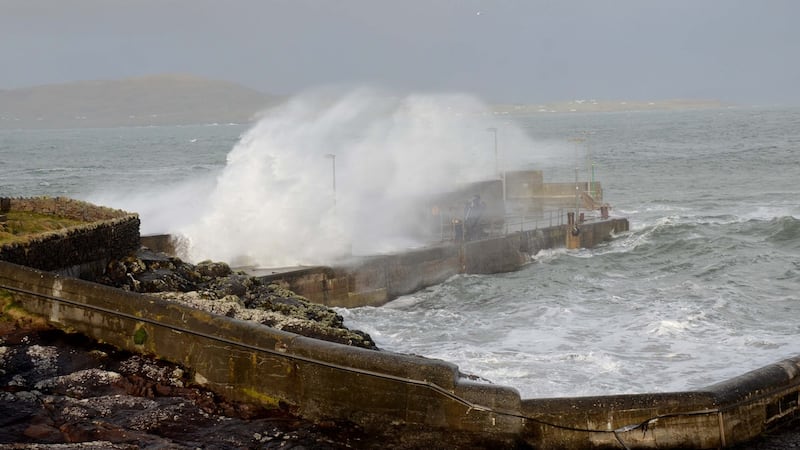
A windsurfer who took to the waves off the coast of Kerry had to be rescued by the RNLI on Thursday night.
Fenit RNLI launched in gale force 9 conditions to search for a windsurfer reported missing off Brandon Bay in county Kerry.
The volunteer lifeboat crew was called out by the Irish Coast Guard shortly before 7.30pm after the alarm was raised by a windsurfer on shore.
Coxswain John Moriarty and six crew members were making there way to the scene 14 nautical miles from their station when news came through that the windsurfer had made it to shore by himself and was safe and well.
Speaking following the call out, Ger O’Donnell, Fenit RNLI Lifeboat operations manager advised people to “Stay Back – Stay Dry – Stay High” as Storm Lorenzo continues.
“I would like to commend the 14 crew members who turned up at the lifeboat station this evening willing and selflessly prepared to go out despite the gale force conditions,” he said.
Wind speeds
Met Éireann had warned that wind speeds would exceed 130km/h in exposed areas causing storm surges which will produce coastal flooding and damage.
While Munster would be largely dry, the rest of the country would experience heavy rain with amounts varying from 25mm to 60mm on higher ground in the space of 18 hours, Met Éireann said.
Though Storm Lorenzo will be relatively short-lived, it will trail more wind and rain in its wake with a further 25mm of rain expected on Saturday and the same amount nationwide on Monday.
However, Jim Casey from the Office of Public Works said there was little chance of rivers flooding as most were well within their banks at present.
Mr Casey said the presence of “swell waves” was a “particular concern and may give rise to wave overtopping on the west coast and potentially along the northwest coast”.
Swimmers criticised
Schools in orange alert counties are being advised to “err on the side of caution” and close on Friday if they feel there is a risk to students from the impact of the storm.
The Irish Coast Guard appealed to the public to stay away from coastal areas during the poor weather, advising: “Stay back, stay high and stay dry.”
In Galway, there was criticism of swimmers who entered the water at Salthill in defiance of warnings from the emergency services.
Local Labour councillor Niall McNelis said: “Anybody who entered the water today, after being told not to, no matter how good of a swimmer they are, is nuts.
“They’re not just putting themselves at risk, if somebody gets in trouble that means that the emergency services will have to go out and rescue them.”
In Kerry, Killarney National Park was closed to the public on Thursday afternoon and a number of events were cancelled.
In Limerick, temporary flood defences were deployed along the quays in the city centre as a precaution. A temporary emergency provision homeless service was opened on Thursday afternoon and “for additional hours on Friday morning”, the local council said.
In Sligo, a coastal road in the west of the county - near the village of Easkey - was closed as a precautionary measure, and various evening events were called off.
Earlier, Paddy Mahon, chief executive of Longford County Council and chair of the local authority body that sits on the National Emergency Response Group (NERG) of the local authorities, detailed other steps being taken in different counties:
- In Cork, the Dursey Cable Car had been suspended;
- In Clare, the council's crisis management team had met, and a lot of protective work had been put into Lahinch which is an exposed area;
- In Galway, the aquadam at the Spanish Arch was in place and road closures were being implemented in Salthill, while sandbags were made available for collection across the county;
- In Mayo, the county council issued a level 3 flood alert at 9am, and was focusong on Crossmolina, Westport and Newport, Achill and Belmullet.
Cork was removed from the orange alert area by forecasters on Thursday morning where forecast wind gusts were reduced from 130km/h to 120km/h.
Yellow alert
A yellow wind alert is in place for the rest of the country from 9am on Thursday to 6am on Friday with gusts of 100km/h expected in most places.
A rainfall warning for Connacht, Leinster, Cavan, Monaghan and Donegal from 9am on Thursday until 6am on Friday.
Ms Cusack advised the public to be prepared for some wet and windy weather, with a risk of some fallen trees and coastal flooding and perhaps some damage along the west coast.
“The storm is approaching, the pressure is falling rapidly. It looks as if it won’t be as bad as it could be given its tropical origin.
"But we still expect significant winds on the west coast with a risk of some coastal flooding and damage, very high waves coinciding with low pressure and also high tides," she told RTÉ Radio's Morning Ireland.
“Because the ground is saturated, the ground is very wet so the trees are in full leaf, and that’s why we’re giving more impacts from this level of winds than if the storm were happening in January.
“There is certainly a high risk of trees down.”
Storm Lorenzo “is a different beast from Ophelia,” she said. “Of course every storm is different, both were hurricanes. Lorenzo lost its hurricane status 1,000km from the southwest of Ireland yesterday afternoon, while Ophelia remained a hurricane very close to Ireland, within 500km.”
Fallen trees
The Health and Safety Authority has urged workers to pay particular attention to the risk posed by trees as the storm passed on Thursday evening.
“Many workers particularly those involved in storm repair, construction, farming and transportation will be facing increased hazards.
“Unfortunately, two people lost their lives during Storm Ophelia while cutting and clearing windblown trees. The HSA has issued a warning to anyone planning on using a chainsaw to cut down fallen trees,” it said in a statement.
The Health Service Executive has warned those with private wells or who are on shared water schemes to note that during severe weather events their water supply may become restricted or reduced.