About 25,000 years ago on a fine late Ice Age day, you could have happily skied off the great snow dome that then covered Glenveagh and the surrounding glens and mountains, and continued all the way gradually downhill out to the Atlantic Ocean ice shelf. Along the way, you would have avoided the spectacularly crevassed ice-fall above the Poisoned Glen, and admired the dramatic nunatak of Errigal, with its drape of steep ice couloirs cutting deeply into the hard quartzite of the summit cone.
Even then though, the days of ice were numbered. By about 11,000 years ago, the land would have emerged, battered and beaten but beautiful, into seasons of sun and rain and changing colour. The last dead ice block remnants would be gone, and the last icebergs would have melted in the slowly warming and encroaching Atlantic. But nobody would have seen all this; our first ancestor hunter/fisher people, in their flimsy coracles, would only have come wandering the flooding inlets and islands of a pristine Donegal coast maybe 2000 years later. The land though would long remember the ice, and would carry down to us the story of those times in the pages of the textbook glacial landscape, and wonderful hiking country, of north Donegal.
The elements had mellowed by the time we came to that country on a recent visit. That said, Met Éireann’s Donegal rainfall alert prompted a low breakfast mood for us in the really lovely, but rain-swept, An Oige Errigal Hostel in Dunlewy. Soon, however, we were kitted out and at the National Park Visitor Centre, already enthralled by the profound beauty of Glenveagh around us.
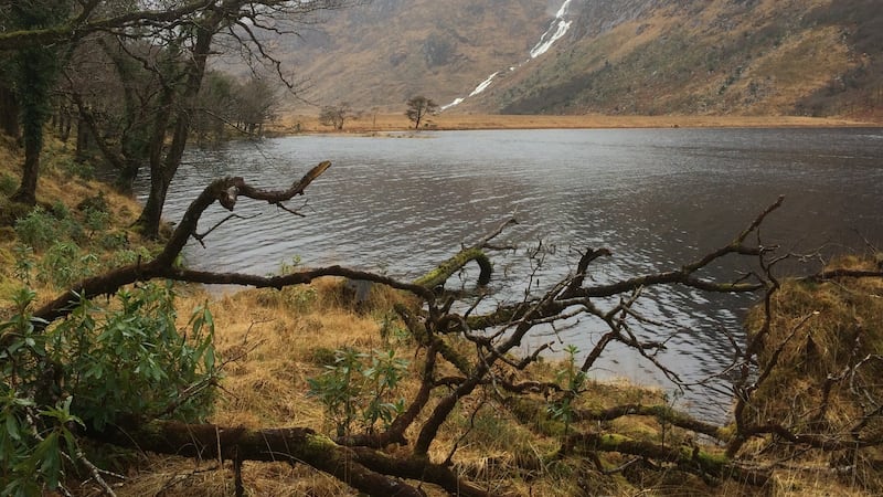
Our plan was to walk to Glenveagh Castle and Gardens and on up the track to the head of beautiful Lough Beagh. There, we would take the footbridge over the river and on to the foot of the Mare’s Tail Waterfall, ascend by its left side, traverse Dooish and descend to our car on the R251.
Our disappointment to find the bridge gone – for “health and safety reasons”, the park later told us – was more than compensated for by the fact that the rain stayed away. Lunch was postponed until we found a spot upstream where the Owenveagh river braided, and all six of us crossed safely and with dignity intact.
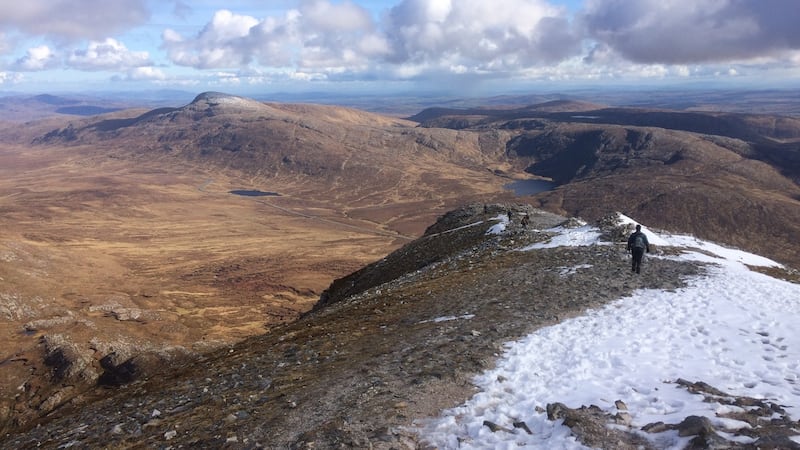
The very spectacular waterfall approach was unfortunately now a non-runner; and so we headed straight up on to the spine of the Derryveagh Mountains, and contoured in calm conditions around to Dooish summit from the west.
The cloud base had lifted as we walked, unveiling a silent snow-spotted mountainscape under strange grey evening light. The cloud hung loose and still above us, seemingly as confused as we were by the profound, almost unnatural, hush.
Our detour upriver had slowed us and head torches were needed in our descent to the car. But “fortune had favoured the brave” that day, and allowed us to stay essentially dry against all the odds!
Map: OSI Discovery Series sheet 6
Getting there: Glenveagh National Park, about 14km west of Kilmacrennan
Effort: 630mts of climbing, about 14km and about 4hrs
Suitability: Moderate fitness required, mountain navigation skills and experience essential; care required on river crossing