
Ireland is set for further battering from high winds, flooding, stormy seas and snow, according to the Government's crisis management team.
The team, which has been monitoring recent storms and issuing weather warnings, said members of the public should not take any risks during Storm Eunice which arrives on Friday morning.
Storm Dudley abated on Wednesday night, after winds reached highs of up to 100km/h.
#StormDudley
— Dublin Fire Brigade (@DubFireBrigade) February 16, 2022
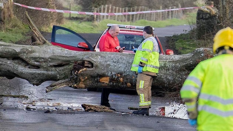
Church Road, Mulhuddart is currently closed following a tree falling as a result of high winds.
Firefighter/Advanced Paramedics from Blanchardstown fire station responded to the scene and crews from @Fingalcoco are working to remove the tree. @DCCTraffic pic.twitter.com/bu7WDTVo3q
The weather is expected to be somewhat calmer on Thursday, with no weather warnings in place, though it is still expected to be blustery.
However, Met Éireann said conditions on Friday would be "challenging", with heavy snow expected in the north and northwest of the country, and high winds across western and southern counties.
ESB Networks said "a few thousand homes" lost power during heavy rain and high winds on Wednesday. The homes that lost electricity were mostly in the midlands and northwest, with the ESB saying Tullamore, Co Offaly, was particularly affected by the loss of power to about 1,600 people.
The status-yellow wind warning associated with Storm Dudley expired at 11.30pm on Wednesday, but the national forecaster said it expected conditions on Thursday to be more mild, with a chance of sunny spells.
A yellow wind warning for Northern Ireland expired at 6am on Thursday, according to the UK Met Office.
Strengthening winds
However, Thursday’s respite is expected to be short-lived. Heavy showers, cloud, rain and strengthening winds are expected on Thursday night ahead of the arrival of Storm Eunice.
Met Éireann said a status-orange wind warning will be in place for counties Galway, Clare, Cork, Kerry, Limerick, Waterford and Wexford as Storm Eunice tracks across the country from 5am to 11am on Friday .
Storm Eunice will also bring a status-yellow wind, rain and snow warning for the entire country for Friday, coming into effect at 1am and lasting until 3pm. The worst of the snow and sleet is expected in the northern half of the country, while the high winds are expected in the south.
It is expected Friday’s storm will be “short and sharp” which could mean red warnings in some parts of the country.
In addition, a status-orange gale and storm force warning for all Irish coastal waters and the Irish Sea will come into effect from midnight on Friday, until 9pm Friday evening.
Met Éireann hydrometeorologist Jennifer Canavan said Ireland was "in a period of high tides at the moment and this in combination with strong winds and stormy conditions means there is a high risk of large coastal waves and coastal flooding on Friday, especially along southern and eastern coasts.
“As such we’re urging people to take extreme care near coastal areas and paths.”
A status-yellow marine gale warning is in place for all coasts of Ireland and on the Irish Sea until noon on Thursday, with winds expected to reach gale force 8 or strong gale force 9.
‘Challenging conditions’
Met Éireann meteorologist Matthew Martin said Storm Eunice was expected to bring further challenging conditions, "as strong winds, heavy rain and snow moves across the country".
“At the moment it looks like northern and western areas are most likely to see the heaviest snow falls, with southern areas expected to see the strongest winds. However, we’re still a few days ahead and the details of when and where are likely to change,” he said. “With this in mind, we’re urging people to keep a very close eye on the forecast and warnings for their area as these may change in the coming days.”
The Government’s crisis management team is monitoring the situation and further updates will be issued on Thursday morning.
In a statement on Wednesday evening it said that only necessary travel should be undertaken during periods of orange weather warnings.
Around the country precautionary measures are being taken in case of flooding. Waterford City and County Council has said flood barriers for the City and Passage may be deployed on Thursday afternoon and the situation is being actively monitored.
The Road Safety Authority has appealed to road users to exercise caution over the coming days.
Meanwhile, Gas Networks Ireland said it does not anticipate any disruption to gas supplies during this week’s forecasted storms.


