

When the weather is good, there is so much to do outdoors in Ireland – solo, or with family or friends. Here are seven activities - with locations, descriptions, tips and some maps for a general guide.
Below you can read John O'Dwyer's pick for a great walking path, Conor O'Keeffe on a running route, Rozanna Purcell recommends a hiking trail, Mary McCarthy on an outdoor swimming location, Ian O'Riordan picks a cycle trip, Sylvia Thompson on a family-friendly park and Fiona Alston selects a popular outdoor gym.
And remember, whatever you do and wherever you go, please be safe. And enjoy.
Name Slievenaslat and the Lake Loop
Distance 8km
Approximate duration 2.5 hours
Difficulty Strenuous
Starting point Google Maps Castlewellan Forest park (grid reference J 335
365); you can follow this NI Walk guide
Amenities Parking and restaurant
From the trailhead, follow the arrows up a steep but relatively short climb to the summit of Slievenaslat, where you are rewarded with fantastic views of the lordly Mourne Mountains. Afterwards, descend to Castlewellan Lake and return to your starting point by circumnavigating these tranquil waters.
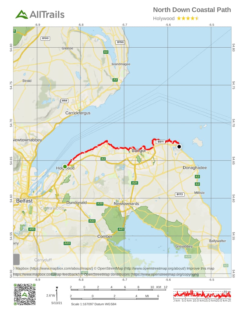
Name: North Down Coastal Path
Length: 25km
Terrain: Bitmac, Stone & Grass Paths
Nearest Town: Holywood, Co Down
Route type: Linear
Route Information: Beach, Coastal, Parkland & Grassland
Dogs: Dogs are allowed. Dogs must be kept under close control
Footwear: Road or Trail Runners
Route Information: The run begins at the Esplanade in Holywood. Head under the railway arch and turn right. Follow the linear path along the outer edge of Belfast Lough towards Seapark. This is a recreational area with a play park. (It may be a great place to take the kids on your rest day from running.) Continue past the park towards the Royal North Yacht Club. From here follow the public footpath as it rejoins the Coastal Path. At this point a detour to the right will lead to the Ulster Folk and Transport Museum and the railway halt. Continuing on the path leads to Craigavad, with the Royal Belfast Golf Club on your right. Beyond this point cross the bridge in front of Rockport Primary School. About 3km further round the coast, a set of steep steps takes you inland at the Seahill Sewage Treatment and rejoins the coast path as you descend at the far end.
Take some time to admire the views of the Irish Sea with some breathtaking coastal scenery. Feel the coastal breeze breathe life back into your legs as you meander through the North Down Coastal Path. From here the path leads to Crawfordsburn Country Park, passing Grey Point Fort, Helen's Bay and through to Crawfordsburn Beach. Grey Point Fort is one of the best preserved early 20th century coastal forts anywhere in the Ireland. Leaving the path briefly, cross Swineley Bay and pick up the path at the far side. If you need a break then on a sunny day stretch out on the sandy beach in the bay and take in some vitamin D. Continue walking along the path to Wilson's Point, where the path turns towards Bangor Marina.
From here follow the path round to Ballyholme Beach, which leads to the National Trust area of Ballymacormick Point. The path continues to Groomsport Harbour, where the path becomes rural in nature, crossing the beach area round towards Orlock Point, Portavo. A small lay-by indicates the end of the run. You can set up a collection point here or if there are two of you running, park one car at the end and one at the beginning.
Aided by: Trek NI
Hike name Slieve Donard
Distance 9.5km
Elevation gain 799m
Approximate duration 3-3.5 hours
Difficulty Advanced
Route type Out and back
Starting point See AllTrails Slieve Donard
Amenities Toilets; the car park is in the town, so plenty of cafes around
Dog-friendly? Yes
Tips Pack an extra warm layer for the top, as you'll be taking in the 360-degree views and a well-deserved break for a while, and it's always very windy up there
Note Due to fire in the Mourne Mountains, Northern Ireland Fire and Rescue Service declared a major incident last weekend and the public was urged to stay away. Please check before embarking on this route
Name: Carlingford Lough
Location: Google Map: JC Campbell garage, Rostrevor
Brief description: Rocky lake shore
Amenities: Parking
Lifeguard: No
Water quality: Moderate. Expected to be upgraded to good with improved wastewater initiatives introduced in 2020
Tips: No need for swimming shoes as there's a slipway (Rostrevor boat club) for easy access. Water levels remain high an hour or two either side of high tide (changes every day check Google/Tides Near Me app before). Drink in sublime views of Cooley mountains and the Mournes while you paddle.
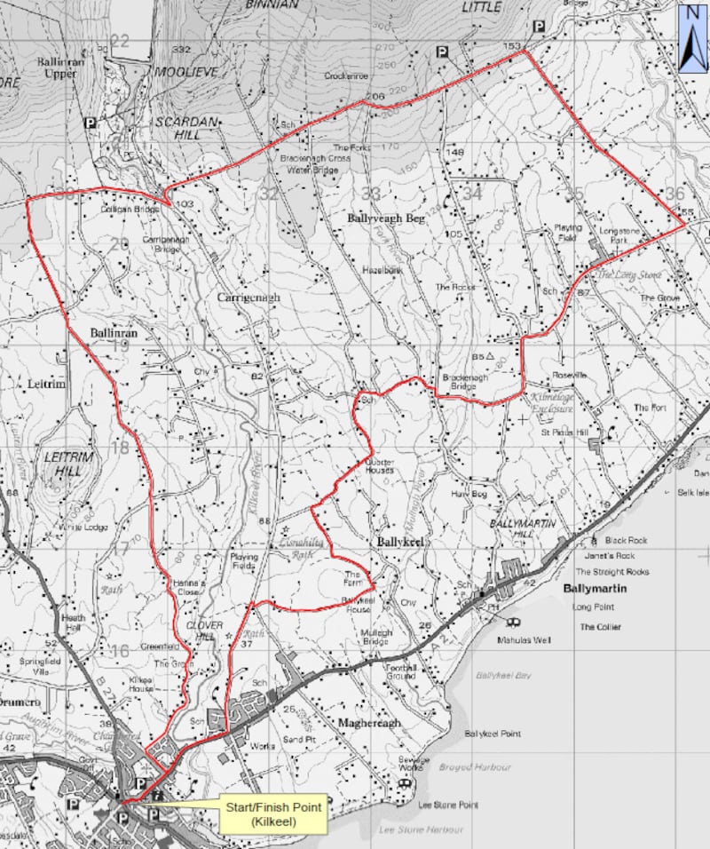
Name: Head Road Route
Start location: Kilkeel
Route: A moderate cycle beneath the high Mournes, via the Silent Valley, with views across the Irish Sea, to the nearby Cranfield Beach, returning via Ballyveaghmore.
Distance: 25km
Time: 2-2.5 hours
Highlights: The mostly quiet country roads with seemingly never-ending views.
Look out for: The Head Road with its panoramic views of the mountains, coastal plain and sea.
Tips: After leaving the town of Kilkeel all roads are country roads; for more see cycleni.com
Park name: Castle Espie Wetland Centre, Ballydrain Road, Comber
Amenities: Home to Ireland's largest collection of exotic and local birds, there's also natural play parks, a zip wire, a duckery, bird-watching hides and great views across Strangford Lough.
Special features: The Sustainability Trail teaches children about protecting nature.
Access: On site parking and bus no 11 from the Laganside Bus Centre in Belfast. Adults £8.54 (€9.90) child £4.72 (€5.50), see wwt.org.uk Google Map "Castle Espie Wetland Centre".
Dogs: assistance and guide dogs only.
Tip: Wear clothes and footwear that you don't mind getting dirty.
Name: Moneyreagh Community Outdoor Gym
Equipment: Leg press, bench general, chest press, seated row, hand bike, lat pull-down, shoulder press, recumbent bike.
Location: Google Maps
Get Active Series
- 32 great walking routes in Ireland - one in each county
- 32 great hikes in Ireland
- 32 great running routes
- 32 great outdoor swim locations
- 32 great cycling routes
- 32 great parks
- 32 great outdoor gyms


