|
Cuilcagh, Co Cavan
Start: Road to mast on the R200, just beside Bellavally Gap between two tracks that are very close together at 120245 and 121245. |
You would be hard put nowadays to find anyone heading for the hills not armed to the teeth with “high-tech” rain gear, all-weather backpacks, walking poles and God knows what other paraphernalia the marketing people throw at us. What a joy it is, then, to find how little of this gear we need to climb Cuilcagh Mountain, on the Cavan-Fermanagh border, on a fine summer’s day.
The route our three guides have chosen for us involves the use of two cars, to avoid having to walk through high heather full of dangerous holes, or too much bog. We leave the first at a farm gate on a boreen off the R206.
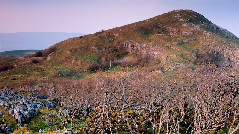
The walk starts at a small road that leads to a mast, on the R200 just after Bellavally Gap coming from Ballinamore, in Co Leitrim. This road, which is not marked on the map, lies between two tracks that are very close together at 120245 and 121245.
If you look up the hill you can see the top of the mast; this will confirm that you are on the right track.
The ascent is gentle for most of the way, winding up past forestry for the first few hundred metres, then moving on to the open mountain and up along a ridge. Far below, an undulating landscape of bog and stream stretches away east into the far distance.
Walking close to the ridge gives the best views and sensation of height, but after about three and a half kilometres, when you have reached the “B” of Binn Chuilceagh on the map, it is time to move in from the edge, to avoid boggy ground and, particularly in bad weather, to avoid danger.
As you approach the summit the landscape changes dramatically, as the first of a series of extraordinary rocky sculptures starts to appear. In fading light or shadowy mists even the most rational of hillwalkers might believe they suddenly see a dog on a rock or a dolphin about to leap into the air.
Thousands of years of weathering have eroded the sandstone mountain top and sculpted the rocks into extraordinary shapes. Giant fissures have appeared that on closer inspection reveal naturally formed gardens of ferns and mosses with ponds in their depths.
The summit stretches for nearly three kilometres, with steep cliffs on the north and east faces. Great flat rocks are piled one on top of another, almost as if manmade, with occasionally a cleverly placed cushion of mosses forming a comfortable seat on which to sit and admire the view.
“Take care you don’t fall into Fermanagh,” one of our guides jokes as we stand at the top and look down at what seems to be an enormous semicircular plateau far below the ridge.
This whole area, which includes Co Fermanagh’s Marble Arch Caves and Cladagh Glen nature reserve as well as Cuilcagh, is now classified as a geopark. The inclusion of parts of Cavan in Marble Arch Caves Global Geopark is regarded as a great example of international co-operation, as it is the first time such a park has extended across an international border.
If you are out for a lazy day’s exploring, take time to zigzag across the summit, looking into the fissures and examining the strange rock formations.
Your final goal before the descent will be the spot height 596m. The circular pile of rocks, probably an ancient burial mound, can be used for a quick stop, but do not confuse it with a fairy fort, which, we were told, should not be touched, as that would bring bad luck.
Leaving this spot, cross the fence and follow it down through a wide gully, heading over to the very high ground on your left. In poor visibility, and if your map-reading skills are not up to scratch, stay with the fence, which goes down steeply and turns sharply left at some forestry. Keep the fence on your right-hand side all the way down.
Alternatively, follow a contour around the side of the mountain well below the steep cliffs until you can see the second coniferous plantation far below you. Head for that and eventually you will come upon the fence that makes a sharp turn to the right.
Walk down between two fences and soon you should see a derelict stone cottage. Assuming you haven’t offended the fairies, your car should be where you left it on the other side of the gate.


