

When the weather is good, there is so much to do outdoors in Ireland – solo, or with family or friends. Here are seven activities - with locations, descriptions, tips and some maps for a general guide.
Below you can read John O'Dwyer's pick for a great walking path, Conor O'Keeffe on a running route, Rozanna Purcell recommends a hiking trail, Mary McCarthy on an outdoor swimming location, Ian O'Riordan picks a cycle trip, Sylvia Thompson on a family-friendly park and Fiona Alston selects a popular outdoor gym.
And remember, whatever you do and wherever you go, please be safe. And enjoy.
Name Commons Loop
Distance 4km
Approximate duration 1.5 hours
Difficulty Moderate
Starting point Google Maps Tourist office, Carlingford (grid reference J 189 115); you can follow this Sport Ireland guide
Amenities Cafes, pubs and restaurants
Follow the green arrows as the walk ascends on to the foothills of the Cooley Mountains. The route then crosses the lower slopes of Slieve Foye while offering a memorable vista along the coast and across Carlingford Lough to the dreamy outline of the Mourne Mountains.

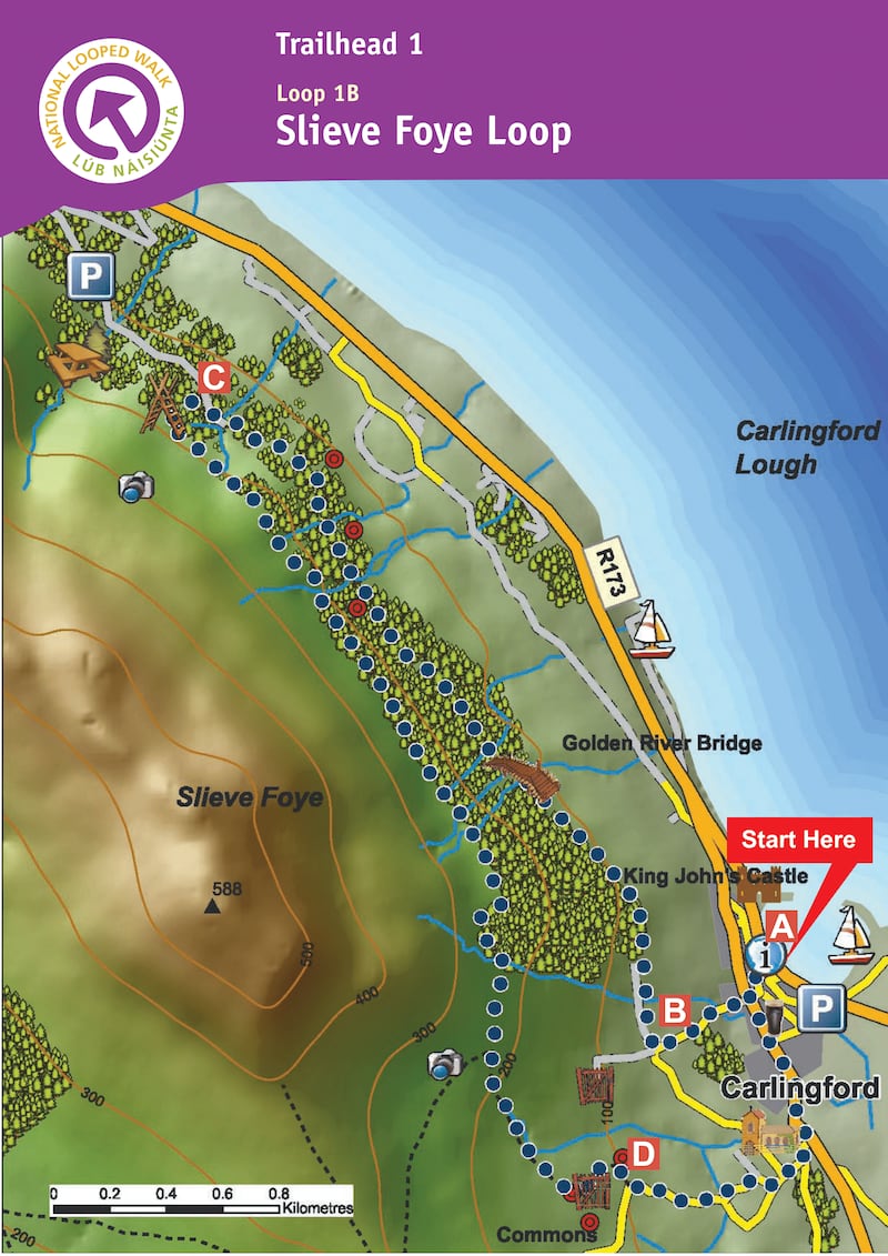
Name: Slieve Foye Loop
Length: 9km
Waymarkers: Blue arrows
Route type: Loop
Elevation: 270m
Footwear: Road or Trail Runners
Dog Policy: Dogs are not permitted on farmland.
Route Information: This National loop walk brings you up to the mountains slopes above Carlingford. The walk is mostly on good paths marked with blue arrows. From the car park turn left and follow the blue (and green and red) arrows along the road to a T-junction where you turn left. The green arrows are for the shorter Commons Loop, the red for the longer Barnavave Loop. Entering the village "square" turn right and ascend to the main junction where you proceed straight on to the right of Savages Victuallers. Continue to follow the green, blue and red arrows (and the yellow arrows which are for the long-distance Táin Way) as the loop takes you to the top of River Road. The green loop goes straight ahead here – but you turn right onto a sandy roadway.
Follow the blue, red and yellow arrows along the roadway past gates and into forestry. The loop travels through the forestry for more than 1km before reaching a forestry track (on the left) where the two loops turn left and leave the Táin Way. Now you ascend gently to reach the edge of forestry and a 20m climb takes you to a stile over a wire fence. Cross the stile, turn left, and follow the wire fence for 1km to reach the end of the forestry. Veer right here. Continue to follow the blue and red arrows for 300m to reach a bend in a grassy roadway where you rejoin the Táin Way. The red loop turns right here – but you veer left and downhill. Follow the grassy roadway for 500m to reach a wooden gate – pass through it and follow the arrows to the left. The loop now sweeps downhill and right and, after 500m, joins a surfaced roadway. Here you rejoin the Barnavave Loop and turn left and downhill. The loop takes you down to the parish church on the outskirts of the village and then turns left and back to the village square. It's only 100m from there to the trailhead. (Aided by: Visit Louth & Sport Ireland)
Hike name Slieve Foye
Distance 7.8km
Elevation gain 491m
Approximate duration 2.5-3 hours
Difficulty Intermediate
Route type Out and back
Starting point See AllTrails Slieve Foye
Amenities Toilets, car park in the town, so lots of shops/cafes/pubs around for afterwards
Dog-friendly? No
Tips There is parking at the start of the trail head, but parking down at the tourist office is a must to pass through the gorgeous town of Carlingford
Name: Clogherhead
Location: Google Map: Clogherhead beach car park
Description: The beach at the bathing area is gently sloping into the sea
Amenities: Toilets, first aid, car park
Lifeguard: Summer months
Water quality: Excellent – Louth County Council Sampled on 07/09/2020
Tips: Bathing area is 1,430m in length so there is always adequate space. The beach at the bathing area gently slopes into the sea so suitable for kids. However, there are two small rip currents at the north end of the beach – advice if you get caught is to identify which direction the current is moving and swim parallel to the shore to the left or right of it – never against it.
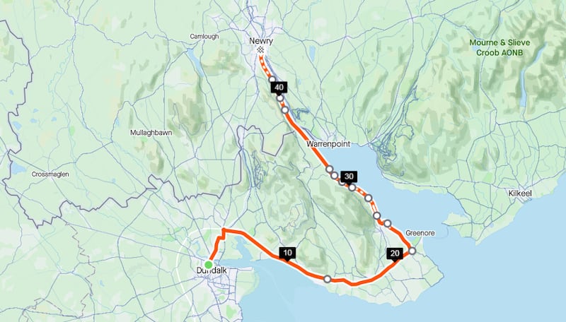
Name: The Great Eastern Greenway
Start location: Dundalk
Route: Can be enjoyed from either direction, rewarded with plenty of fine views, especially the stretch from Carlingford to Omeath to on the old Dundalk, Newry and Greenore railway line.
Distance: 42km
Time: 3-4 hours
Highlights: Another family-friendly cycle that rewards patience with plenty of pleasure.
Look out for: Views across to the Mourne Mountains and Slieve Foy from Louth side.
Tips: Another route not to be rushed, especially over the old level crossings.
Park name: Ravensdale Forest Park
Amenities: Magnificent mixed woodland with walking trails including a walk to the summit of Black Mountain (506m) and the popular Ravensdale looped walk/run. Plenty of archaeological features.
Special features: Two longer walking routes – The Táin Trail and The Ring of Gullion Way - pass through Ravensdale Forest.
Access: Car park on site. Google Map "Ravensdale Forest Park".
Dogs: Dogs on leads.
Tip: Check the weather forecast before setting out on longer walks.
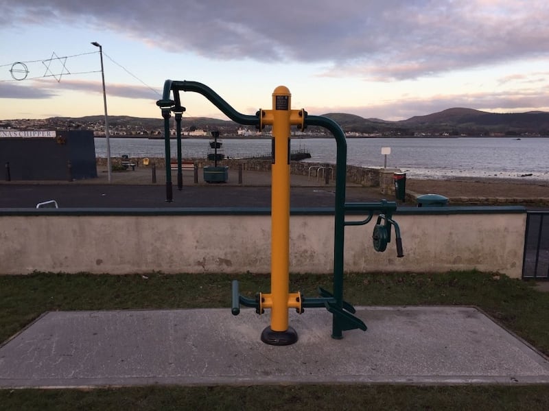
Name: Omeath Outdoor Gym
Equipment: Fitness rider, walker, chest press, lat pull-down, dip bars, chin-up, stepper, leg press, ab curl, cross trainer, rotator, shoulder flexor, hand cyle, body twist, bicycle, rower.
Location: Google Maps
Information: This outdoor gym is on the greenway from Carlingford, so there is plenty of opportunity to get a walk or a run in nearby with great views of the Lough.
Get Active Series
- 32 great walking routes in Ireland - one in each county
- 32 great hikes in Ireland
- 32 great running routes
- 32 great outdoor swim locations
- 32 great cycling routes
- 32 great parks
- 32 great outdoor gyms


