In the third and final act of Brian Friel’s play Translations, the hedge school teacher Hugh outlines one of the play’s central messages: “It is not the literal past, the ‘facts’ of history, that shape us, but images of that past embodied in language... we must never cease renewing those images; because once we do, we fossilise.” Hugh is speaking here with a certain resignation in the face of the Ordnance Survey, the extensive colonial mapping project which transformed the language of Ireland’s landscape from the 1820s to the 1840s, dispersing the Irish language and asserting the dominance of English as a linguistic key to the land. The schoolmaster articulates the necessity of renewal in these moments of coerced transition, warning that “a civilisation can be imprisoned in a linguistic contour which no longer matches the landscape of... fact”.
Hugh’s words of warning come to mind when looking at the recently approved centenary stone at Stormont. This is the sculpture which was crafted to “celebrate” the 100-year anniversary of Northern Ireland in “a tangible and meaningful way”, according to Arlene Foster, Steve Aiken and Jim Allister. The stone was requested to be installed in the grounds of Stormont in early 2021 by the (then) three leaders of the main unionist parties in the north, who had offered to foot the bill for its creation and installation. In a letter to the speaker of the Assembly, Sinn Féin’s Alex Maskey, who was head of the Assembly Commission which decided the centennial programmes, they warned that “the response will signal to those we represent the scale of respect available to them from the Assembly authorities”.
After Sinn Féin vetoed the proposal, Maskey explained the decision to reject the stone on the basis that it served the wishes of one community only. However, a technicality emerged after John O’Dowd, Sinn Féin’s representative on the Commission, was appointed minister for infrastructure, leaving an unfillable vacancy on the commission. In February, when the stone was proposed again, the SDLP’s Dolores Kelly voted for it along with the other members, explaining her decision as being made in “a spirit of generosity”.
Even when the flag which became known as the Ulster Banner was eventually designed, it featured a red hand, set within a six-pointed star and a crown, enshrining a long fixation with the number six as a partitionist mantra
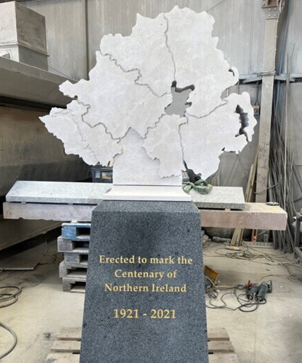
Recently finished by stonemason Alan McConnell, and standing at over two metres tall, the artwork seems to have taken the form of a tombstone. A map of the six counties of the North sits on a granite plinth, mostly blank except for those engraved features which outline the borders between the counties as well as Lough Erne and Lough Neagh. In gold lettering on the plinth are etched the lines “Erected to mark the Centenary of Northern Ireland, 1921-2021″, resembling more epitaph than birthday greeting. The map-icon was carved from Portland stone, envisaged to match the material of Parliament Buildings at Stormont, the stone entirely in keeping with the unionist overtone of the estate’s art and architecture.
READ MORE


Rather than a victory for unionism, however, its belated arrival is signal of a deep problem within the tradition, the language and imagery which defined it for 100 years no longer resembling the landscape of fact. The shape of the stone faithfully expresses the “not an inch” mentality that has defined northern unionism since at least the beginnings of Northern Ireland. The stone also reflects a tendency towards forgetting the conditions and circumstances in which Northern Ireland was created. Then again, “Ulster” unionism has always been more comfortable in celebrating the geography of partition rather than its history. Its imagination has often been heavily topographical, a litany of maps and placenames that image a separation of north from south. Though Northern Ireland was initially something of a consolation prize, unionists quickly reimagined it as destiny rather than chance. In the early 1920s, when they sensed a threat in the form of the looming Boundary Commission, they turned to the map as the icon of the six counties. “Now that the Boundary issue has been raised once more, a map of Northern Ireland should be in every home,” proclaimed the Belfast Weekly News in 1923, promising a free map in the paper’s yearbook for the next year.
When the British Empire Exhibition opened at Wembley, London in 1924 – running for two years with 27 million visitors, the largest exhibition the world had ever seen – the new Northern Ireland struggled with designing an appropriate flag for its “Ulster” pavilion. Rejecting the designs for a new flag, it emblazoned the building with the names of each county and prominently featured a large electric map at the entrance which purported to show the industries of the region, but it also found good use as political capital in the shadow of the Boundary Commission. Even when the flag which became known as the Ulster Banner was eventually designed, it featured a red hand, set within a six-pointed star and a crown, enshrining a long fixation with the number six as a partitionist mantra. When the commission ended in late 1925 with an unqualified victory for the northern government, the six-county map was still used to amplify the now “settled” Border. It was, as Seamus Heaney later recalled, placed on the walls of classrooms as a way of imprinting “an official Northern Ireland and establishing a six-county-centric point of view from the start”, in so doing relegating “the rest of the island to a political and geographic nowhere”.
The interwar construction of the Parliament Buildings within the Stormont Estate at a time of a deeper economic crisis is another case in point, the building of its foundations partly funded by siphoning public money from its unemployment relief fund. Its English architect, Arnold Thornely, was tasked with designing a building that would be a monument to the permanence of the North as a separate entity to the South. As a result, what became known simply as Stormont prominently featured the number six across its neoclassical style, the six columns at the front of the building complemented by its six floors, and the Prince of Wales Avenue constructed as a framing device lined with lime trees. Its 365ft length added a signal of its temporal permanence to these more obviously loaded references to the union and Northern Ireland. The building has served since as an effective symbol of unionist government in the North, not least because the term “the Stormont government” has been interchangeable for Northern Ireland even in the years before 1933, when it was officially opened.
This return to the map as an icon is less a moment of triumph than a reminder of the fears that still haunt northern unionism
Underlining this enchantment with the number six and the deep contradictions that pervaded these expressions of an eternal “Ulster”, when Edward Carson died in 1935 his state funeral in St Anne’s Cathedral included a ritual scattering of soil from each of the six counties on his coffin. As the Belfast News Letter explained this claim to the Dubliner Carson as the figurehead of “Ulster”: “Although not, in the strictest sense of the term, an Ulsterman, he was of the stuff of which Ulstermen are made.” His statue had already been erected outside Parliament Buildings before his death and unveiled in what the historian Gillian McIntosh considers as a ritual of state. These early decades set a pattern of representation which has rarely changed since its creation. From the Festival of Britain in 1951 to Ulster ‘71, maps of the territory cut off from the rest of the island have rarely been out of sight for big celebrations or commemorations of Northern Ireland, reflecting how often unionism returns to this imagined geography in moments of anxiety.
The echoes with their current predicament are profound. When set alongside Sinn Féin’s attendance of the coronation of King Charles III and the DUP’s recent attempted reignition of the long-settled Drumcree dispute, the centenary stone appears simply as another front in what unionists have described as a “culture war”, a reactionary term weaponised to portray an embattled community. This “war” is in one respect a legacy of the Troubles which, as the poet and essayist Padraig Regan has written, has “not resolved as such, but metastasised into a purely symbolic conflict”. As the money from the “peace dividend” has dried up in Northern Ireland, and the social and economic effects of Brexit and the pandemic linger, symbolism is now the art of the possible in the North.
If such a culture war exists, it has done so since at least the beginning of Northern Ireland, when the geography of partition began to be solidified, and the distinctiveness of the six counties was presented as an always-existing fact – something that you could point to on a map. As the centenary stone attests to, visual culture has remained a prominent field of this battle, the hollowed-out image of the North floating free of Britain and the rest of Ireland, showing more concern for the Border itself than what is contained within it. This return to the map as an icon is less a moment of triumph than a reminder of the fears that still haunt northern unionism in the second century of partition. The map may still be the territory, but that is now the problem, since both are running out of time and out of space.
Stephen O’Neill is Irish Research Council Enterprise Research Fellow at the School of English, Trinity College Dublin and the Irish Museum of Modern Art