Donald Trump showed a map of Hurricane Dorian’s projected path on Wednesday that appeared to have been altered with a pen to include the state of Alabama.
The ÜS president in a weekend tweet had named Alabama as one of the states that could be hit. The National Weather Service denied that in a tweet 20 minutes later.
“Alabama will NOT see any impacts from #Dorian. We repeat, no impacts from Hurricane #Dorian will be felt across Alabama. The system will remain too far east,” the National Weather Service in Alabama tweeted.
In a White House video released on Wednesday Mr Trump points to an official weather chart dated August 29th showing the states that could be hit in what the National Hurricane Center calls the “cone of uncertainty”.
A curved line had been added to the cone on the chart to show a risk that Dorian could move from Florida to Alabama.
“It was going to hit not only Florida, but Georgia, it could have, it was going towards the Gulf, that was what we, what was originally projected . . . ,” Trump says in the video.
However, Dorian was never projected to be heading toward the Gulf of Mexico, where Alabama has a coastline.

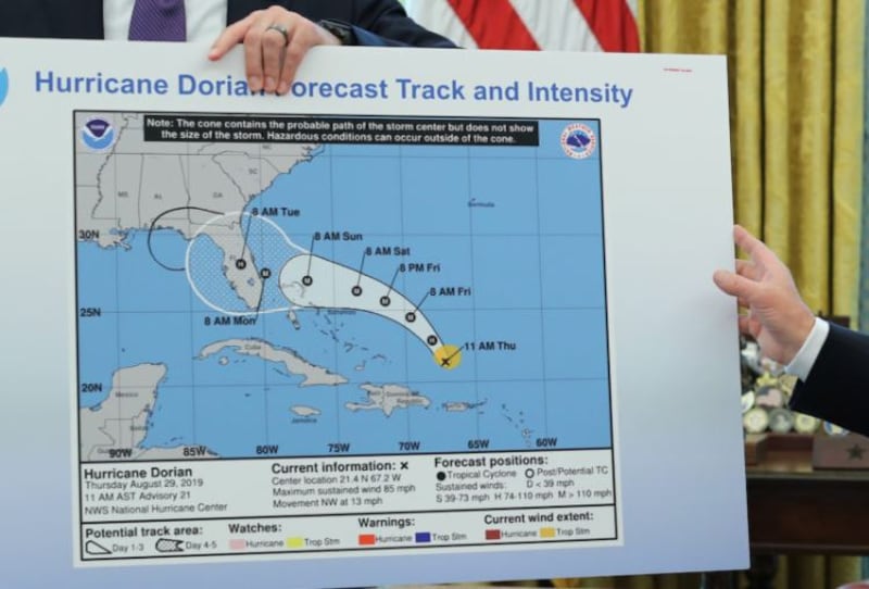
In his Oval Office remarks, the president argued that on the “original chart”, Dorian was going to hit Florida directly “and that would have affected a lot of other states”.
“But that was the original chart,” he said.
When reporters later asked Mr Trump whether the chart had been drawn on with a Sharpie pen, the president said: “I don’t know; I don’t know.”
Altering official government weather forecasts is against the law. – Reuters, Guardian