Severe weather affects us all and we need to know when to take action to protect ourselves and our property.
We have become familiar with the colourful spectrum of warnings issued by Met Éireann. For several years Met Éireann has issued warnings of extreme weather. These depend on the severity of the meteorological event and the level of confidence in the forecast. They are formulated using forecasts produced by computer, algorithms that determine the likely impacts of extreme weather, and the expertise of the forecasters.
During anomalous weather periods a suite of warnings are issued as necessary each morning, and are updated as new information becomes available. Met Éireann collaborates with, and provides support to, other agencies to decide on strategies to mitigate damage to property and to reduce the risk of loss of life. Warnings are normally issued within three days of the expected adverse weather but advisories may be issued earlier, up to a week in advance.
The warning system supports impact-based decision-making for several agencies. Local Authorities normally co-ordinate responses to severe weather emergencies. For broader or more extreme scenarios, the National Emergency Coordination Group (NECG) springs into action. This brings together all government departments and relevant agencies and organisations to ensure co-ordination of the response to emergencies.
READ MORE

Met Éireann currently uses a hybrid threshold/impact-based warning system. There are three warning levels, yellow, orange and red. The relevant weather thresholds are detailed on the website www.met.ie, and a chart of warning criteria can be downloaded from there. Met Éireann is transitioning to a fully impact-based forecasting system in which the focus of warnings is on potential impacts of weather rather than on the numerical values attained by the weather elements themselves.
The colour coding of warnings is consistent with that used by the European agency Meteoalarm. Yellow signifies weather that may be dangerous locally, but that is not a widespread threat. Orange indicates infrequent weather conditions that pose a threat to life and property over a broader region. Red warnings are for very dangerous weather conditions associated with widespread, intense meteorological phenomena.
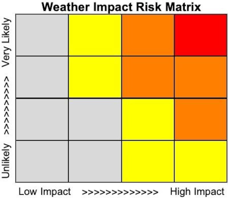
The basis for issuing impact-based warnings can be explained using a schematic diagram known as a risk matrix. The horizontal axis of the risk matrix represents the impact; the vertical axis indicates the probability of the event.
Moving horizontally to the right, the impact varies from very low to extremely high; moving vertically, the likelihood of the predicted event increases from unlikely to very probable. The expected damage level is the product of probability and impact. For example, a likely event of medium severity and a possible event of high severity may have a similar values of expected damage or economic loss; both might be covered by an orange warning.
No forecast is perfect: for many reasons errors are unavoidable. To allow for this computer models are solved with a range of slightly different starting conditions and “forcings”. The collection of forecasts is called an ensemble.
If the atmosphere is in a stable disposition the forecasts resemble each other for several days. If it is in a turbulent mood they diverge rapidly. The spread of the ensemble gives us a measure of the uncertainty of the forecasts and the probability that any given one is correct.
This uncertainty is of great value: with the ensemble system we can quantify the probability of any severe or extreme weather prediction. This gives us the vertical position in the risk matrix. The horizontal position depends upon the severity of the predicted weather. The product of these parameters determines the appropriate level, or colour, of the warning.
Peter Lynch is emeritus professor at the school of mathematics & statistics in University College Dublin. He blogs at thatsmaths.com


