There’s a pleasant sensation of falling into another world when you swing your bike off the busy road opposite the Dropping Well pub in south Dublin and plunge down the path along the River Dodder.
All the angry noise of a cross-city ride falls suddenly away; before you know it you’re gliding under the soaring piers of the nine-arch bridge, a landmark viaduct that once lifted the Harcourt Street railway line above the river valley and now carries the Luas.
You find yourself moving through a green corridor alongside a river of surprising drama and beauty. Its spectacular weirs, evidence of vanished heavy industry, make the brown water foam and hiss in spate, all silvers and creams.
Then you pass the Packhorse bridge, a neglected gem of 1650s stonemasonry that is badly in need of restoration. Pausing on its span, you may see grey wagtails below, their vivid yellow bellies flickering in reflection on the river as they dance among the stones, hunting flies.
If you are lucky you may glimpse a dipper, a white-bibbed and portly small brown bird. It has the surprising trick of walking under water, its eyes protected by transparent lids. The dipper’s presence here suggests that the ecosystem is relatively healthy.
You might even find otter spraints, which is to say droppings, on a nearby rock.
But soon you have to dismount and cross the busy road at Milltown. Thereafter you will be squeezed in perilously against the pavement by passing cars, on the narrow road alongside the river past Beaver Row to Donnybrook.
It may be soon be possible, however, to follow much more of the river, on foot or by bicycle, without having to divert on to so many main roads.
Glenasmole to Ringsend
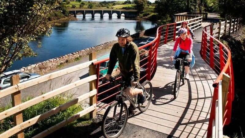
Plans are afoot to create a greenway along most of the river’s 29km, from Glenasmole in the Dublin Mountains to Ringsend and Dublin Bay. Three local authorities – South Dublin County Council in the lead, plus Dublin City Council and Dún Laoghaire-Rathdown – and the National Transport Authority are working on it.
It's a promising idea, taking its lead from similar routes around the country – the Great Western Greenway is the best known – but perhaps the most exciting thing about it is the richness of the responses that the initial feasibility study report on the greenway proposal, produced by the engineering consultancy Roughan & O'Donovan, has evoked from community groups along the Dodder.
"A network of guardians of the river has emerged," says Tara de Buitléar, who is chairwoman of Tallaght Community Council. Her group has made a detailed submission on the options for the greenway from Glenasmole to Oldbawn.
Knocklyon Network has done likewise for the middle section, including Firhouse, and the Dodder Action group has produced an exceptionally comprehensive study for the stretch from Bushy Park to Ringsend.
The impressive detail involved in all these responses to the feasibility study speaks eloquently of the breadth and depth of local environmental passions in communities along the river. They raise diverse concerns about the greenway’s potential impact on built heritage, on plants and wildlife, and on recreational interests; about the ecological consequences of proposed new bridges, about flooding, and about the spread of alien invasive plants.
These documents, and the study itself, also highlight a challenging but inevitable reality: there is often no single “correct” solution to environmental problems; painful choices frequently have to be made.
No environmentalist could quarrel with the broad aims of the greenway report, which aims to get many more commuters out of cars and on to bikes. That reduces our carbon emissions and is good for public health.
But when you try to combine what one biking group hails as a “cycling superhighway” with a “greenway”, goals inevitably clash. Greenways are supposed to cater to a wide variety of users, enhance biodiversity and support ecological corridors.
“We were excited until we looked at the detail,” says John Lacy, chairman of Dodder Action. “We are fully behind the greenway, but we want to avoid negative impacts on architectural and ecological heritage. We want it all to be well thought through. Everyone will have to compromise.”
This is almost as true within the community groups as it is between the groups and the councils. The ideal riverside route for a dog walker is not the same as the best greenway for a birdwatcher or an angler. This is one of the things that make the community groups’ responses so refreshing – many different perspectives are acknowledged.
After some initial difficulties in setting up meetings, Lacy is hopeful that the authorities will take the community groups’ points seriously, but there is still a great deal to be resolved.
Carving out riverbank
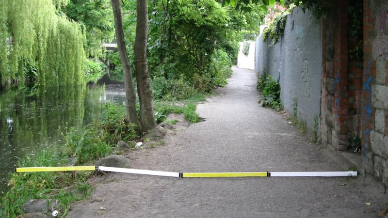
The study advocates that the cycleway element be four metres wide. Richard Good, who led the Dodder Action study, had the bright idea of photographing a four-metre stick laid down at key points along the route. These images demonstrate the effects, on other users and on natural and architectural features, of carving out so much riverbank space for cyclists.
Good, a cyclist himself, hopes that the tranquil riverscape will in itself encourage cyclists to slow down. “Why would you go flying along if it’s a nice place?” he says. He argues that, as cyclists are supposed to stop for traffic lights, it’s not too much to ask them to respect pedestrians on the greenway.
Dodder Action’s submission suggests a useful guideline for future discussions: “The proposal should adapt to the existing river and its unique natural environment of riverbanks and associated public open spaces,” not vice versa.
Given the multiple interests involved in debating the nature of the greenway, there is a good case for applying the Environmental Protection Agency's new integrated catchment management model to the Dodder, Lacy agrees. The EPA model is a tailored approach to issues such as this, and includes multiple environmental, economic and cultural aims.
The agency’s catchment management unit is meeting the local authorities involved shortly. With luck all concerned will seize this opportunity to engage communities in enhancing the River Dodder.
Get to know the Dodder: opportunities to explore
Dodder Action Dublin is reissuing Christopher Moriarty’s wonderfully informative Down the Dodder, which Wolfhound originally published in 1991, as an ebook this month.
It says: “For all its small size, the Dodder is a stream of great character. The enchanted valley of Glenasmole caught the attention of the earliest Irish storytellers. Monasteries were built beside the river and waterworks were well established when the first historical reference to the weirs was set down in 1244.”
And: “Several writers in the 17th century referred with awe to the Dodder’s propensity for spectacular flooding – floods which have remained beyond human control to the present day. But the bounty of the Dodder has been more significant than its turbulence . . . it acts as a lifeline, bringing wild plants and birds and other creatures to brighten the most heavily built- up areas.”
There are many ways to enhance your appreciation of the Dodder today. Dodder Action Dublin (dodderactiondublin.com) holds its walk from source to sea on April 9th; Dodder Action Day – the river-long community clean-up organised by Dodder Action Dublin, Tallaght Community Council (facebook.com/tallaghtcommunitycouncil) and Knocklyon Network (knocklyonnetwork.com) – is on April 23rd; Dodder Heritage Day is on August 27th; and Kiltipper Ramblers (kiltipperramblers.com/calendar) organise frequent upstream Dodder walks.