Maps have an air of authority about them: they have always been a way of defining territory, setting out the lie of the land. They chart how things are, or how they seem to be at the time; they have a claim to objective truth, factual reality.
But Irish map-maker and author Garrett Carr doesn't see it that way at all. While his maps are just as precise and scientifically correct as any official publication, Carr's passion is for charting unexpected connections across space and time, chance encounters, fictional locations.
He describes his work as a kind of “optimistic cartography”, an antidote to stark and divisive political maps, with their crude fragmentation of orange and green. More than that, it’s a way of seizing the world and tracing a different path through it, marking his own footsteps, making it new. “An individual can take on an entire landscape,” says Carr, “they can claim that power.”
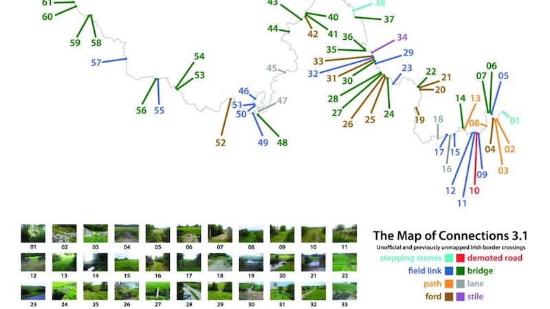
For The Map of Connections, Carr travelled the length of the Irish Border, seeking out unofficial crossing places. He went mostly alone, and on foot, though on the last stage, along the Foyle water system, he paddled his way by canoe with his friend, the artist Paddy Bloomer.
Carr set himself the rule that to qualify for inclusion on the map, the crossings – stepping stones, gates, stiles and so on – had to be previously uncharted, not found on any other map, and still in use. Making the map meant witnessing at first hand a landscape that is normally thought of in symbolic terms, as opposed to an actual place.
For the most part, it was a long, lonely journey. “I spent about two months on the Border in total, camping out and slowing making my way from east to west. I thought I would meet people, but actually it was very quiet. It reminded me of the Eastern bloc border with Germany, that narrow strip running right down the middle. Political turmoil had preserved it, and it was the same here. My abiding impression was of nature run wild. In the absence of anyone to talk to, I found myself reading people by the signs they’d left behind, it was like the archaeology of the recent past.”
One of the strangest structures Carr came across was a big steel bridge, standing in the middle of nowhere, with no clues to its origins or function. On another occasion, he found himself on Cuilcagh Mountain, on the border between Co Cavan and Co Fermanagh.
“There was an enormous bit of blanket bog, beautiful and desolate, and I was just following a wire fence across it. The Border is almost always attached to something; it rarely just goes across a field. There’s usually a wall, or a hedge, or a stream, or a fence. But this time I felt as far from other people as you can possibly be.”
Human connections
Later, on Holywell Hill near Derry, Carr met a farmer in the process of making a footbridge across the stream that constituted the Border at this point. (As he points out, two thirds of the Border is water.) In the course of conversation it emerged that the farmer’s son had married a woman from just over the Border in Donegal and he was building a walkway between the two farms. “That was a very romantic connection,” smiles Carr.
There was also plenty of time for thinking about the nature of the land he was walking, and its place in the public imagination. “There’s a dichotomy at the heart of the Border,” says Carr. “It’s about division, staying on your side of the line. But it’s also a place to meet, for difference to interface. There’s always that instability about it.”
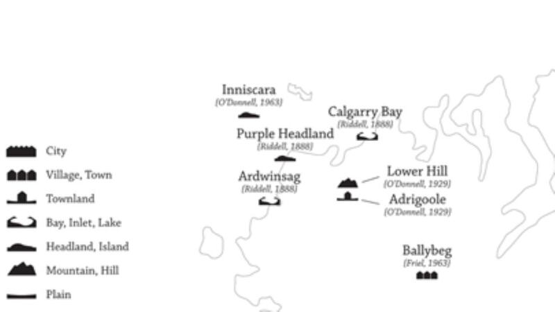
Another map, Fictional Ulster, aims to answer questions like: where exactly is Brian Friel's Ballybeg, and where is the setting of the 1937 comedy film Oh, Mister Porter, Buggleskelly? "It struck me that not actually existing was no real bar to being a fictional place. These locations have become written into the landscape, they acquire weight. And certain writers define certain places. So you have a lot of Patrick McCabe down by the Border, while Sam Hanna Bell is Co Down."
The Map of Watchful Architecture identifies "watching" or defensive structures such as forts, crannogs, checkpoints, watchtowers, even lighthouses. One of the most surprising things about this map is that it creates connections across time as well as geographical space. For instance, Carr uses the same symbol to indicate a modern immigration checkpoint as he does for a 1,000-year-old earthwork wall designed to funnel people towards an approved frontier point.
So how does Carr find his way when he’s striding out through remote bogs and ancient, overgrown paths? “Well, I use ordnance maps and GPS to guide me. I did lose the borderline a couple of times, you find yourself in the wrong hedgerow. But you have to approach it with almost militaristic care; it’s like hiking with precision.”
Does he feel some sense of ownership of the land he’s marking out? “No, not really. I’m more concerned with getting it right, getting the right answer. I feel there’s a right way of doing it and I have to find that. It’s a process that needs integrity, rigour. The map is not an illustration, you’re claiming something scientific.”
The art of map-making
At the same time, Carr regards his maps as works of art in themselves. “Like any piece of art, you’re trying to put forward your own vision. But map-makers are a fairly disparate bunch, working individually, probably in a shed at the bottom of the garden, and frequently they have no sense that what they’re making are valuable art objects in their own right.”
Carr recently attempted to remedy this by curating a show at the Ulster Museum, Mapping Alternative Ulster, which brought to light all kinds of strange and beautiful maps by independent local cartographers, and also included his own striking work. One of Carr's favourites, Friend Map, made by John Carson in 1976, marked the locations of Carson's friends, using black and white passport photographs, across Belfast and beyond, connecting them all up with carefully-ruled lines.
“This was made at the height of the Troubles, in one of the bloodiest years,” says Carr, “yet it tells a completely different story about what was going on here at the time.”
Telling a different story: that’s the essential job of the creative map-maker. For Garrett Carr, his maps are always a work in progress; there is, and never will be, a final answer.
Yet while many of the things he documents might seem humble or mundane in themselves, taken together they suggest something more: an affirmation of our fundamental connectedness, or, as Carr says himself, “a hopeful statement about human irrepressibility”.