
Can we envision Dublin before a city stood by the Liffey? What sort of environment did Dubliners of 1014 live in? We can make some reasonable guesses, partly with the help of archaeology and geology.
First, Dublin Bay in its natural state came in as far as Grattan Bridge, which joins Capel Street and Parliament Street; everything to the east is built on infill.
Second, the River Liffey was about 300m wide at high tide and therefore fordable only at low tide. It was also subject to flash floods and potentially dangerous.
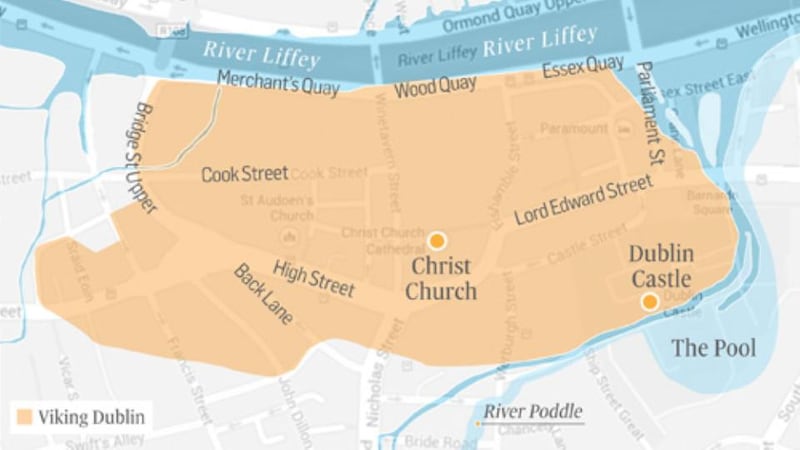
Third, its tributary the Poddle helped to define a defensible site at the end of the east-west ridge on the south bank of the main river. A tidal pool in the Poddle provided a perfect location for a Viking fleet.
Vikings became adept at choosing locations for sea- and land-based communications. They also favoured sites on political boundaries, to exploit local tensions and tap into existing exchange mechanisms. Dublin, on the northern boundary of the province of Leinster, had lots of potential. The fringes of Dublin Bay may have been unprepossessing slobland, but that did not matter to skilled and experienced sailors.
The hinterland, too, was full of agrarian resources. It was long settled by the native Irish, who practised mixed farming. One element must have been barley, for the local southside district of Cualu – including some of north Wicklow – was famous for its ale.
The archaeology of Viking Dublin has demonstrated, among other things, that ash trees were being coppiced to provide posts for houses and fences.
Dublin was already a place where one could hope to live well. It was a centre of communications by land and sea. Four long-distance routes of prehistoric origin converged in the bay, facilitating travel to and from Britain. Viking Dublin was by far the most important Scandinavian settlement in Ireland. It is no exaggeration to suggest that the Battle of Clontarf was a battle for Dublin.
According to a later literary account with a strong Munster bias, Sitric Silkbeard, the king of Dublin, did not fight on that fateful day. Instead he watched the proceedings from the “battlements” of the town.
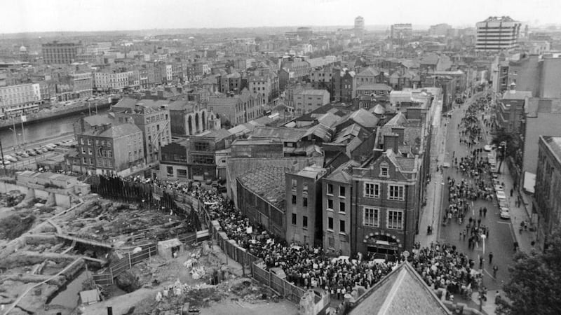
What was the nature of Dublin’s defences? Extensive archaeological investigations, at Wood Quay and elsewhere, mean we have a reasonable idea. What was labelled “Bank 3” at Wood Quay consisted of an earthen embankment with an external ditch about two metres wide. Presumably, it was surmounted by a wooden palisade.
Dublin’s defences had been strong enough to prevent a Munster army capturing the town in the autumn of 1013. Very possibly these defences had been rebuilt after the burning of Dublin by an earlier army under Brian’s command, following his decisive victory over the Dubliners at the Battle of Gleann Máma, fought southwest of Dublin on December 30th, 999.
Fear of a repetition of that experience may have been one reason Sitric remained behind the defences in 1014. His role would have been to command a defensive force in the event of a Munster victory. Brian’s death and that of his son and preferred heir, Murchad, prevented that.
If we ask ourselves what those defences enclosed in 1014, the short answer is a rare phenomenon in contemporary Ireland: a town. Back in the days of Sitric’s father, Olaf Cuarán, effectively king of Dublin from 952 to 980, a Viking trading emporium had evolved into a recognisable town. Its economy had become progressively less dependent on the raiding of monasteries and the enslavement of captives. Craftworking and regular trading had become the norm.
Towns were still a novelty in Ireland. Before Brian Boru became king of Munster, the Dál Cais had taken control of Viking Limerick by eliminating its ruling family. Thereby he would have become aware of the profits to be extracted from townspeople in the form of tribute. By becoming the overlord of the southern half of Ireland in 997, Brian acquired access to the much greater wealth of Dublin.
Visible wealth
Around that time this wealth had become even more visible, as a locally produced currency. Modelled on English silver pennies, this currency was the first issued in Ireland. The moneyers may themselves have been brought over from England, from where Danish Vikings were then extracting huge sums as tribute. Now Dublin's tributary payments could be handed over in a form much more portable than cows.
The wealth of Dublin was being generated inside houses and workshops and on Liffey quaysides. The archaeology has been remarkably consistent, in that a range of building types has been uncovered in numerous locations. These have been classified in a generally accepted scheme by Dr Patrick Wallace.
The dominant type of house had post-and-wattle walls and a pitched roof resting on a four-post structure. Standard internal features were a central hearth with seating and sleeping areas on both long sides. Access was by doorways in the shorter walls, on the street frontage and facing the rear of each plot.
There were no windows; some of the smoke from the fire probably escaped through an opening in the roof. But the interior remained smoky, though cosy. There would have been an almost total lack of privacy for the occupants – parents and children, grandparents if they survived, and even domestic slaves. Family life would have been close, to say the least.
Paths and lanes have been excavated, sometimes making use of parallel logs. No main street has yet been accessible; the presumption is that streets that existed in 1014 underlie modern ones. Likely candidates are what we know as Castle Street, Christchurch Place and Fishamble Street. The latter still retains a broadening in the middle, representing the medieval fish market.
Street life would have been raucous and vibrant. The estimated 3,500 inhabitants spoke Irish and Norse; many were probably bilingual. Foreign traders came and went, some no doubt from England as speakers of Anglo-Saxon, or Old English. A Dublin colony on the island of Anglesey (“Ongul’s Island”) was in the making, and Welsh may have been heard as well.
Animals were to be seen and heard everywhere: horses, cows, sheep and pigs; cats and dogs; fowl and geese. They were kept to be useful, as food and as craftworking materials. Animal bones are one of the commonest archaeological finds – and cause both consternation and delight: how are they to be identified, counted, recorded and interpreted?
One type of building appears to have been completely absent inside the defences: the church. The religious composition of Dubliners in 1014 is uncertain. Despite his presumed Christian upbringing, King Sitric spent the winter of 1013-14 conspiring with "pagan" Norsemen to secure their support.
Only later, after his return from a pilgrimage to Rome in 1028, did he see fit to enshrine Christianity as the official religion of his townspeople, by his foundation, with Bishop Dúnán, of Christ Church.
The Battle of Clontarf had more to do with politics than with religion. Reminiscent of the first World War, it was to some extent a family affair. One of those families was resident in Dublin – that of King Sitric, his Irish wife and his Irish mother. Nothing akin to a royal hall has yet been identified archaeologically, but a distinct possibility is that it stood on the site of the later castle, overlooking the tidal pool in the Poddle from which Dublin derives its international name.
At the close of that day in 1014 much of Sitric's family lay dead. Yet he himself had survived to tell the tale, if not always as he would have wished. Myth-makers stepped in, and only now, after a millennium, are we starting to unravel the truth.
Howard Clarke is professor emeritus of medieval socio-economic history at University College Dublin


